IMAGES TAKEN NEAR TO
East Hecklegirth, ANNAN, DG12 6HP
Introduction
This page details the photographs taken nearby to East Hecklegirth, DG12 6HP by members of the Geograph project.
The Geograph project started in 2005 with the aim of publishing, organising and preserving representative images for every square kilometre of Great Britain, Ireland and the Isle of Man.

There are currently over 7.5m images from over14,400 individuals and you can help contribute to the project by visiting https://www.geograph.org.uk
Image Map
Images are licensed for reuse under creativecommons.org/licenses/by-sa/2.0
Notes
- Clicking on the map will re-center to the selected point.
- The higher the marker number, the further away the image location is from the centre of the postcode.
Image Listing (9 Images Found)
Images are licensed for reuse under creativecommons.org/licenses/by-sa/2.0
Image
Details
Distance
1
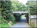
Rail overbridge on the old Solway Junction Railway
The Solway Junction Railway linked Brayton on the Maryport and Carlisle Railway with Kirtlebridge on the Caledonian Railway Main Line. Opened in 1869, this section was closed in 1921 when the Solway Viaduct was closed to traffic. It is not certain what current use is made of the trackbed over the bridge which crosses Seafield Road.
Image: © Oliver Dixon
Taken: 2 Sep 2013
0.11 miles
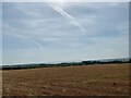
3
Field with Triangulation Pillar at Watchhill
Looking southward.
Image: © Peter Wood
Taken: 20 Sep 2014
0.14 miles
4
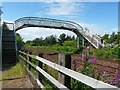
Railway footbridge, Annan
Crossing over the Glasgow to Carlisle south western line, taken from Annerley Road. On the other side is a grassy area leading to sports fields and allotments, and a path to Solway Street.
For a closer view see Image .
Image: © Rose and Trev Clough
Taken: 3 Jul 2010
0.19 miles
5
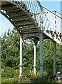
Railway footbridge - detail of ironwork
Showing the decorative touches on Image This section of line was opened in 1848 by the Glasgow, Dumfries and Carlisle Railway Company - presumably the bridge was put up then, but we cannot find any information to confirm this.
Image: © Rose and Trev Clough
Taken: 3 Jul 2010
0.19 miles
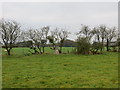
6
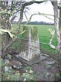
Watch Hill
Grazing land outside Annan. The pillar is in a hedge that has been neglected and is now grown out.
Image: © Richard Webb
Taken: 15 Mar 2004
0.20 miles
7

Annan from the air
The town of Annan on the northern edge of the Solway Firth. A poor image due to the cloud haze and the photographer is about two or three kilometres to the South just above Bowness-on-Solway.
Image: © Willie Duffin
Taken: 11 Oct 2010
0.22 miles
8
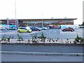
Tesco's Annan
Partly built on the site of Annan Shawhill Station on the dismantled Solway Junction Railway.
Image: © Oliver Dixon
Taken: 2 Sep 2013
0.23 miles
9
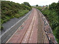
Railway Improvements, Annan
View of the recently completed track doubling just east of Annan Station on the Glasgow-Dumfries-Carlisle line. Picture taken from former Kirtlebridge-Annan-Kirkbride railway bridge (1869-21), which now carries a pipeline and footpath.
Image: © Chris Newman
Taken: 15 Jul 2008
0.24 miles