IMAGES TAKEN NEAR TO
Windermere Wynd, DG12 6FH
Introduction
This page details the photographs taken nearby to Windermere Wynd, DG12 6FH by members of the Geograph project.
The Geograph project started in 2005 with the aim of publishing, organising and preserving representative images for every square kilometre of Great Britain, Ireland and the Isle of Man.

There are currently over 7.5m images from over14,400 individuals and you can help contribute to the project by visiting https://www.geograph.org.uk
Image Map
Images are licensed for reuse under creativecommons.org/licenses/by-sa/2.0
Notes
- Clicking on the map will re-center to the selected point.
- The higher the marker number, the further away the image location is from the centre of the postcode.
Image Listing (8 Images Found)
Images are licensed for reuse under creativecommons.org/licenses/by-sa/2.0
Image
Details
Distance
1

Solway Junction Railway
This bridge carries Hospital Road in Annan over the former railway branch line which was part of the Caledonian Railway known as the Solway Junction Railway, running between Kirtlebridge and Annan then crossing the Solway Firth by a 1,940 yard (1,791 m) viaduct to Bowness-on-Solway and Whitrigg. The line was opened with Caledonian Railway backing completely by 8 August 1870. The Scottish part was bought by the Caledonian Railway on 5 August 1873 and the whole line on 6 July 1895. It joined up with the Maryport and Carlisle Railway. This line sought to bring iron ore and hematite from Cumberland to the Lanarkshire steelworks. http://en.wikipedia.org/wiki/Caledonian_Railway
Image: © Andy Farrington
Taken: 3 Apr 2012
0.11 miles
2
Shop in housing estate, Shawhill Road, Annan
Image: © Darrin Antrobus
Taken: 20 Feb 2008
0.14 miles
3
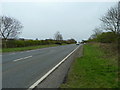
A75 north of Annan
Looking towards Gretna and the M6.
Image: © Andy Farrington
Taken: 3 Apr 2012
0.17 miles
5
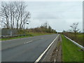
A75 north of Annan
Looking towards Dumfries and Stranraer.
Image: © Andy Farrington
Taken: 3 Apr 2012
0.20 miles
6
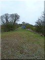
Solway Junction Railway
View of the track of the former railway branch line which was part of the Caledonian Railway known as the Solway Junction Railway, running between Kirtlebridge and Annan then crossing the Solway Firth by a 1,940 yard (1,791 m) viaduct to Bowness-on-Solway and Whitrigg. The line was opened, with Caledonian Railway backing, completely by 8 August 1870. The Scottish part was bought by the Caledonian Railway on 5 August 1873; and the whole line on 6 July 1895.It joined up with the Maryport and Carlisle Railway. This line sought to bring iron ore, hematite, from Cumberland to the Lanarkshire steelworks. http://en.wikipedia.org/wiki/Caledonian_Railway
Image: © Andy Farrington
Taken: 3 Apr 2012
0.21 miles
7
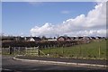
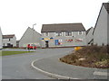
House building Annan
Edge of town, within the bypass. View from Stapleton Road.
Image: © Richard Webb
Taken: 5 Mar 2017
0.25 miles
8
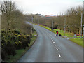
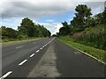
Annan, Stapleton Road
The B6357 approaching Annan.
Image: © David Dixon
Taken: 14 Feb 2013
0.25 miles