IMAGES TAKEN NEAR TO
Scroggie Meadow, ANNAN, DG12 6DY
Introduction
This page details the photographs taken nearby to Scroggie Meadow, DG12 6DY by members of the Geograph project.
The Geograph project started in 2005 with the aim of publishing, organising and preserving representative images for every square kilometre of Great Britain, Ireland and the Isle of Man.

There are currently over 7.5m images from over14,400 individuals and you can help contribute to the project by visiting https://www.geograph.org.uk
Image Map (Loading...)


Getting Data...Please wait
Leaflet Map data © OpenStreetMap
Images are licensed for reuse under creativecommons.org/licenses/by-sa/2.0
Notes
- Clicking on the map will re-center to the selected point.
- The higher the marker number, the further away the image location is from the centre of the postcode.
Image Listing (47 Images Found)
Images are licensed for reuse under creativecommons.org/licenses/by-sa/2.0
Image
Details
Distance
1
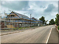
New Housing Development at Annan
Houses under construction on Elm Road.
Image: © David Dixon
Taken: 9 Aug 2021
0.07 miles
2

New Houses on Elm Road
Houses under construction on Elm Road.
Image: © David Dixon
Taken: 9 Aug 2021
0.08 miles
3

Southern edge of Annan town
Seen from Lover's Lane.
Image: © Oliver Dixon
Taken: 28 Sep 2007
0.08 miles
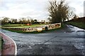
4

Development site on west side of Elm Road
The houses on the north side of the site are on the south side of Wood Avenue. Ordnance Survey documents indicate that in 1974 a benchmark levelled at 16.217m above Newlyn Datum was verified on a gatepost (now removed) at the site entrance
Image: © Roger Templeman
Taken: 4 Nov 2020
0.09 miles
5

Benchmark on NW parapet of railway bridge at NE end of Elm Road
Ordnance Survey pivot benchmark described on the Bench Mark Database at www.bench-marks.org.uk/bm134446
Image: © Luke Shaw
Taken: 29 Oct 2020
0.12 miles
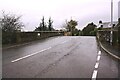
6
Junction of Elm Road and Lovers' Walk
Ordnance Survey records indicate that a benchmark levelled at 16.263m above Newlyn Datum was verified in 1974 on the wall angle left of the grit bin
Image: © Luke Shaw
Taken: 4 Nov 2020
0.12 miles
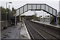
7
Elm Road railway bridge east of station at Summergate Road junction
There is an Ordnance Survey benchmark on top of the left hand bridge parapet
Image: © Luke Shaw
Taken: 29 Oct 2020
0.13 miles
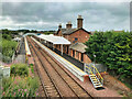
9
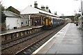
Class 156 number 156513 stops at Annan Station on its way to Carlisle
Image: © Roger Templeman
Taken: 29 Oct 2020
0.14 miles