IMAGES TAKEN NEAR TO
Johnston Street, ANNAN, DG12 5BJ
Introduction
This page details the photographs taken nearby to Johnston Street, DG12 5BJ by members of the Geograph project.
The Geograph project started in 2005 with the aim of publishing, organising and preserving representative images for every square kilometre of Great Britain, Ireland and the Isle of Man.

There are currently over 7.5m images from over14,400 individuals and you can help contribute to the project by visiting https://www.geograph.org.uk
Image Map
Images are licensed for reuse under creativecommons.org/licenses/by-sa/2.0
Notes
- Clicking on the map will re-center to the selected point.
- The higher the marker number, the further away the image location is from the centre of the postcode.
Image Listing (218 Images Found)
Images are licensed for reuse under creativecommons.org/licenses/by-sa/2.0
Image
Details
Distance
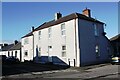
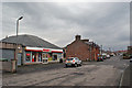
1
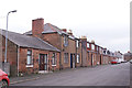
Johnstone Street, Annan
Residential street close to the centre of the town.
Image: © Richard Dorrell
Taken: 15 Dec 2016
0.01 miles
2
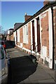
Houses on NE side of Thomas Street
There is an Ordnance Survey benchmark Image on the white stone right of the steps of the nearest house and left of a utilities cabinet
Image: © Luke Shaw
Taken: 4 Nov 2020
0.02 miles
3

Benchmark on No. 6 Thomas Street on NE side of B722
Ordnance Survey cut mark benchmark described on the Bench Mark Database at www.bench-marks.org.uk/bm134437
Image: © Luke Shaw
Taken: 4 Nov 2020
0.04 miles
4
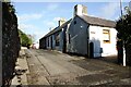
Looking north along Bruce Street
Ordnance Survey records indicate that a pivot benchmark levelled at 15.263m above Newlyn Datum was verified in 1973 on top of the black-painted stones at the base of the road face of the nearest house, about 2 feet from the black gatepost. See www.bench-marks.org.uk/bm134435
Image: © Luke Shaw
Taken: 4 Nov 2020
0.06 miles
5
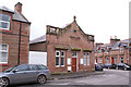
Nursery Place Resource Centre
Located on the junction of Nursery Place and Moat Road, in a largely residential part of Annan. The Resource Centre is a meeting place for people who experience mental illness. A range of activities are on offer, including lunches, games, days out and opportunities to meet other people with similar lived experiences.
The building has the look of having originally been a chapel.
Image: © Richard Dorrell
Taken: 15 Dec 2016
0.08 miles
6
No. 53 Johnstone Street at Butts Street junction
Ordnance Survey documents indicate that a benchmark levelled at 18.173m above Newlyn Datum was verified in 1974 on the near corner, left hand face, of the house to which pebbledash has since been applied. See www.bench-marks.org.uk/bm134444
Image: © Luke Shaw
Taken: 4 Nov 2020
0.08 miles
7
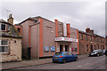
Lonsdale Cinema and Bingo Club
Located in Lady Street, originally the Mechanics Hall and Institute, the building was converted and extended to open as a cinema in 1916. It was transformed into a Bingo Hall in the 1960s. In 1999, two new cinema screens, seating 107 and 56, were created in the front stalls and backstage area.
Image: © Richard Dorrell
Taken: 15 Dec 2016
0.09 miles
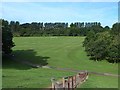
8
Steps into Everholm Park
The park features a six-lane athletics track plus football and rugby pitches.
Image: © Richard Dorrell
Taken: 15 Dec 2016
0.10 miles
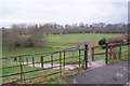
9
Playing fields on Everholm Park
Southern end of the park and playing fields beside the River Annan.
Image: © Oliver Dixon
Taken: 31 Jul 2013
0.10 miles
10
Convenience store, Butts Street, Annan
Standing at the corner of Mill Park Crescent.
Image: © Richard Dorrell
Taken: 15 Dec 2016
0.11 miles