IMAGES TAKEN NEAR TO
Rae Street, DUMFRIES, DG1 1HX
Introduction
This page details the photographs taken nearby to Rae Street, DG1 1HX by members of the Geograph project.
The Geograph project started in 2005 with the aim of publishing, organising and preserving representative images for every square kilometre of Great Britain, Ireland and the Isle of Man.

There are currently over 7.5m images from over14,400 individuals and you can help contribute to the project by visiting https://www.geograph.org.uk
Image Map
Images are licensed for reuse under creativecommons.org/licenses/by-sa/2.0
Notes
- Clicking on the map will re-center to the selected point.
- The higher the marker number, the further away the image location is from the centre of the postcode.
Image Listing (303 Images Found)
Images are licensed for reuse under creativecommons.org/licenses/by-sa/2.0
Image
Details
Distance
1
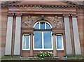
Window, Ewart Library
Carved figures over the window personify knowledge and music.
Image: © Rose and Trev Clough
Taken: 16 Aug 2008
0.04 miles
2
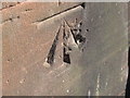
Ordnance Survey Cut Mark
This mark can be found on a wall in Irving Street.
For more detail see : http://www.bench-marks.org.uk/bm45920
Image: © Peter Wood
Taken: 7 Oct 2012
0.05 miles
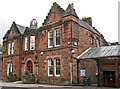
3
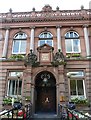
Ewart Library, main entrance
The building is in the Edwardian Renaissance style, with elaborate decoration. For more information on Scotland's Carnegie Libraries, see : http://www.scotcities.com/carnegie/intro.htm
Image: © Rose and Trev Clough
Taken: 16 Aug 2008
0.05 miles
4
Ewart Library, Catherine Street, Dumfries
Money to build the library was donated by Scottish-American steel magnate and philanthropist Andrew Carnegie. It is one of nearly 3,000 to which he contributed worldwide, the first one being in his home town of Dunfermline Image
The library was named after William Ewart, MP for Dumfries 1841-68. He introduced a bill which led to the Public Libraries Acts of 1850 (England) and 1853 (Scotland). This allowed free libraries to be funded from local taxes, although Dumfries did not get one until the Ewart opened in 1904. http://www.dumgal.gov.uk/Dumgal/MiniWeb.aspx?id=33
Image: © Rose and Trev Clough
Taken: 16 Aug 2008
0.05 miles
5
Front of the Loreburn Hall - 43 Newall Terrace
Built in 1890 (date stone over door) for the local Volunteer Militia. There is a splendid pair of carved lions at the entrance, and an ornate metal crown on the roof (for more information see RCAHMS http://canmore.rcahms.gov.uk/en/site/208127/details/dumfries+newall+terrace+loreburn+hall+including+ornamental+lions/ and Historic Scotland http://hsewsf.sedsh.gov.uk/pls/htmldb/f?p=2200:15:0::::BUILDING,HL:26287,26287 ).
Attached to the rear of the building is a large hall - originally the drill hall - which became a popular venue for concerts, shows, sports and dancing. The Loreburn Hall was mothballed when a new leisure centre opened in 2008 Image , but a catalogue of defects developed at the latter. With DG One needing an extended closure for repairs in 2014, the Loreburn Hall was reprieved. Dumfries & Galloway Council have renovated it to provide a temporary fitness suite http://www.bbc.co.uk/news/uk-scotland-south-scotland-29050238 , and subsequently the management of the hall will be taken over by a charitable trust (see the Loreburn Hall Trust's Facebook page, which has lots of photos https://www.facebook.com/pages/Loreburn-Hall/559276494154327 ). Offices at the front have continued in use.
Image: © Rose and Trev Clough
Taken: 9 Jun 2012
0.06 miles
6
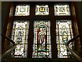
Stained glass window, Ewart Library
The central panel shows a winged figure of St. Michael, patron saint of Dumfries, above the town motto "A' Loreburn". This was an ancient rallying cry, for defenders of the town to gather by the Loreburn stream if an attack was expected. Ironically, the Ewart Library was built over the source of this stream, and has suffered considerable problems with damp because of it. http://www.dumgal.gov.uk/dumgal/MiniWeb.aspx?id=33&menuid=164&openid=164
Image: © Rose and Trev Clough
Taken: 16 Aug 2008
0.06 miles
7
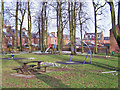
Public park, Academy Street, Dumfries
This small park at the junction of Catherine Street and Academy Street is carpeted with crocus blossom. On the left are backs of houses in Lovers' Walk.
Image: © Richard Dorrell
Taken: 19 Mar 2010
0.08 miles
9
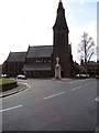
St John the Evangelist Church, Dumfries
St John the Evangelist Scottish Episcopal Church (1868), Lovers’ Walk in Dumfries. In front is the Dumfries bronze and white war memorial.
Image: © Chris Newman
Taken: 4 Apr 2009
0.10 miles
10
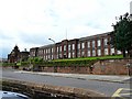
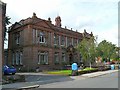
Dumfries Academy
One of four secondary schools in Dumfries. The impressive buildings, on a raised site above Academy Street, are Category B listed. http://hsewsf.sedsh.gov.uk/hslive/hsstart?P_HBNUM=26077
Image: © Rose and Trev Clough
Taken: 16 Aug 2008
0.10 miles