Front of the Loreburn Hall - 43 Newall Terrace
Introduction
The photograph on this page of Front of the Loreburn Hall - 43 Newall Terrace by Rose and Trev Clough as part of the Geograph project.
The Geograph project started in 2005 with the aim of publishing, organising and preserving representative images for every square kilometre of Great Britain, Ireland and the Isle of Man.

There are currently over 7.5m images from over 14,400 individuals and you can help contribute to the project by visiting https://www.geograph.org.uk
Front of the Loreburn Hall - 43 Newall Terrace
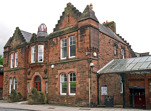
Image: © Rose and Trev Clough Taken: 9 Jun 2012
Built in 1890 (date stone over door) for the local Volunteer Militia. There is a splendid pair of carved lions at the entrance, and an ornate metal crown on the roof (for more information see RCAHMS http://canmore.rcahms.gov.uk/en/site/208127/details/dumfries+newall+terrace+loreburn+hall+including+ornamental+lions/ and Historic Scotland http://hsewsf.sedsh.gov.uk/pls/htmldb/f?p=2200:15:0::::BUILDING,HL:26287,26287 ). Attached to the rear of the building is a large hall - originally the drill hall - which became a popular venue for concerts, shows, sports and dancing. The Loreburn Hall was mothballed when a new leisure centre opened in 2008 Image , but a catalogue of defects developed at the latter. With DG One needing an extended closure for repairs in 2014, the Loreburn Hall was reprieved. Dumfries & Galloway Council have renovated it to provide a temporary fitness suite http://www.bbc.co.uk/news/uk-scotland-south-scotland-29050238 , and subsequently the management of the hall will be taken over by a charitable trust (see the Loreburn Hall Trust's Facebook page, which has lots of photos https://www.facebook.com/pages/Loreburn-Hall/559276494154327 ). Offices at the front have continued in use.
Images are licensed for reuse under creativecommons.org/licenses/by-sa/2.0
Image Location
Latitude
55.07017
Longitude
-3.607967