IMAGES TAKEN NEAR TO
Marchfield Avenue, DUMFRIES, DG1 1GN
Introduction
This page details the photographs taken nearby to Marchfield Avenue, DG1 1GN by members of the Geograph project.
The Geograph project started in 2005 with the aim of publishing, organising and preserving representative images for every square kilometre of Great Britain, Ireland and the Isle of Man.

There are currently over 7.5m images from over14,400 individuals and you can help contribute to the project by visiting https://www.geograph.org.uk
Image Map
Images are licensed for reuse under creativecommons.org/licenses/by-sa/2.0
Notes
- Clicking on the map will re-center to the selected point.
- The higher the marker number, the further away the image location is from the centre of the postcode.
Image Listing (48 Images Found)
Images are licensed for reuse under creativecommons.org/licenses/by-sa/2.0
Image
Details
Distance
1

Dumfries and Heathhall
As seen from above. Heathhall is nearer, and separated from Dumfries by the bypass [A75], which crosses the River Nith thrice in quick succession. The river appears from cloud middle right, and exits towards the Solway Firth at top left
Image: © M J Richardson
Taken: 18 Aug 2010
0.05 miles
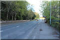
2
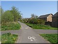
Dumfries to Locharbriggs path
On the trackbed of the Dumfries, Lochmaben and Lockerbie Railway, between a pair of recent housing developments.
Image: © Richard Webb
Taken: 22 Apr 2019
0.05 miles
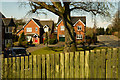
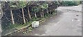
5
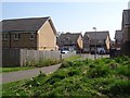
Keswick Place
Some new houses on the edge of Dumfries.
Image: © Richard Webb
Taken: 22 Apr 2019
0.07 miles
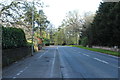
6
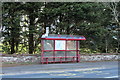
Bus Stop & Shelter, Dumfries
Behind the trees is the Dumfries and County Golf Course. A nice finish to the top of the wall.
Image: © Billy McCrorie
Taken: 17 Apr 2017
0.08 miles
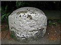
8
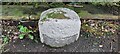
Old milestone
The first milestone on the A710 out of Dumfries towards Moffat near Milehouse Crescent. A 1980s photo shows it twice this height so the path has been built up since then. The recess for a plate can just be seen. The plate would have read EDINBURGH/arrow to left 71/DUMFRIES/1 arrow to right. The plate would have been cast at the Affleck Foundry in the early 1800s. There is a benchmark and pin in the bare patch on the top.
Image: © Jon Glew
Taken: 6 Apr 2024
0.09 miles
9
Old milestone
The milestone 1 mile from the centre of Dumfries on the A701 near to Milehouse Crescent.
Image: © Jon Glew
Taken: 6 Apr 2024
0.09 miles
10
Old Milestone by the A701, Edinburgh Road, Dumfries parish
Dumfries red sandstone by the A701, in parish of Dumfries (Nithsdale District), South of Dumfries by-pass, near the South entrance to Milehouse Crescent, back of pavement, under garden hedge.
Inscription once read:-
(Edinburgh)
(71)
(Dumfries)
(1)
Surveyed
Milestone Society National ID: DG_DFMF01
Image: © Milestone Society
Taken: Unknown
0.11 miles