IMAGES TAKEN NEAR TO
Arrol Place, DG1 1AF
Introduction
This page details the photographs taken nearby to Arrol Place, DG1 1AF by members of the Geograph project.
The Geograph project started in 2005 with the aim of publishing, organising and preserving representative images for every square kilometre of Great Britain, Ireland and the Isle of Man.

There are currently over 7.5m images from over14,400 individuals and you can help contribute to the project by visiting https://www.geograph.org.uk
Image Map (Loading...)


Getting Data...Please wait
Leaflet Map data © OpenStreetMap
Images are licensed for reuse under creativecommons.org/licenses/by-sa/2.0
Notes
- Clicking on the map will re-center to the selected point.
- The higher the marker number, the further away the image location is from the centre of the postcode.
Image Listing (21 Images Found)
Images are licensed for reuse under creativecommons.org/licenses/by-sa/2.0
Image
Details
Distance
1
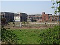
The ruined Arron Johnson factory
Once a car factory, it was recently home to Interfloor. Now distinctly derelict. View from the railway cycle path.
Image: © Richard Webb
Taken: 22 Apr 2019
0.05 miles
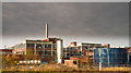
4

Interfloor - formerly Arron Johnson
Factory in an industrial satellite village of Dumfries. This was once a car factory making Arrol Johnson cars.
See http://www.secretscotland.org.uk/index.php/Secrets/ArrolJohnsonFactory
Image: © Richard Webb
Taken: 5 Mar 2006
0.09 miles
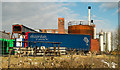
5
Lochthorn Works
This is a rear view of the Interfloor Factory which has closed with the loss of many jobs
Image: © Hugh Close
Taken: 28 Mar 2013
0.10 miles
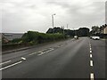
6
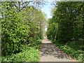
Cycle path between Locharbriggs and Dumfries
On the trackbed of the Dumfries, Lochmaben and Lockerbie Railway.
Image: © Richard Webb
Taken: 22 Apr 2019
0.11 miles
7
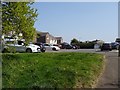
Off Downs Way, Heathhall
Suburban Dumfries.
Image: © Richard Webb
Taken: 22 Apr 2019
0.12 miles
8
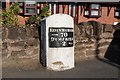
Old Milestone by the A701, Heathall, Dumfries Parish
Dumfries red sandstone by the A701, in parish of Dumfries (Nithsdale District), North of Dumfries by-pass, opposite junction to Kirkton, Heathall, by low stone wall in front of houses, East side of road.
Inscription reads:- : EDINBURGH / {arrow} 70 / DUMFRIES / 2 {arrow} :
Surveyed
Milestone Society National ID: DG_DFMF02
Image: © Milestone Society
Taken: Unknown
0.16 miles
9
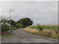
The road to Kirkton
A country lane leaves the A701 to wind its way toward Kirkton and various other villages.
Image: © Peter Whatley
Taken: 20 Sep 2015
0.16 miles
10
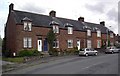
The terrace
A row of terraced houses near Dumfries.
Image: © Colin Kinnear
Taken: 26 Jun 2008
0.16 miles