IMAGES TAKEN NEAR TO
Vallance Drive, LOCKERBIE, DG11 2DU
Introduction
This page details the photographs taken nearby to Vallance Drive, DG11 2DU by members of the Geograph project.
The Geograph project started in 2005 with the aim of publishing, organising and preserving representative images for every square kilometre of Great Britain, Ireland and the Isle of Man.

There are currently over 7.5m images from over14,400 individuals and you can help contribute to the project by visiting https://www.geograph.org.uk
Image Map
Images are licensed for reuse under creativecommons.org/licenses/by-sa/2.0
Notes
- Clicking on the map will re-center to the selected point.
- The higher the marker number, the further away the image location is from the centre of the postcode.
Image Listing (5 Images Found)
Images are licensed for reuse under creativecommons.org/licenses/by-sa/2.0
Image
Details
Distance
1
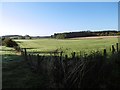
Field off Dumfries Road
The edge of Lockerbie - for now. Behind me is the very busy Dumfries Road which specialises in timber lorries and freight being taken to and from the creamery half way between Lockerbie and Lochmaben.
Image: © Richard Webb
Taken: 8 Oct 2015
0.12 miles
2
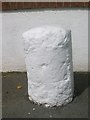
Old Milestone by the A709, Dumfries Road, Dryfesdale Parish
By the A709, Dumfries Road in parish of Dryfesdale (Annandale District), Lockerbie, on pavement, East of junction with Grant Avenue.
Surveyed
Milestone Society National ID: DG_DFLB12
Image: © Milestone Society
Taken: Unknown
0.13 miles
3
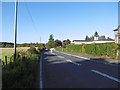
Dumfries Road
The A709 is rather busy with timber lorries and freight going to and from the Arla (it used to be Kerrygold when I looked after a nearby bothy in the 1990s) creamery.
Image: © Richard Webb
Taken: 8 Oct 2015
0.15 miles
4
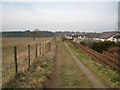
Quaas Loaning
At this unusually named location, a farm track runs between open farmland and the backs of houses in West Acres. The track provides pedestrian access to walks in the Turnmuir Plantation.
Image: © Richard Dorrell
Taken: 4 Mar 2013
0.16 miles
5
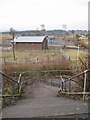
Footbridge and sub-station
The expensively constructed but seldom used footbridge crosses the A74(M) and provides pedestrian access from the West Acres housing development to the southern end of Lockerbie town. The electricity sub station has road access from West Acres.
Image: © Richard Dorrell
Taken: 4 Mar 2013
0.22 miles