IMAGES TAKEN NEAR TO
Well Close, LOCKERBIE, DG11 2BY
Introduction
This page details the photographs taken nearby to Well Close, DG11 2BY by members of the Geograph project.
The Geograph project started in 2005 with the aim of publishing, organising and preserving representative images for every square kilometre of Great Britain, Ireland and the Isle of Man.

There are currently over 7.5m images from over14,400 individuals and you can help contribute to the project by visiting https://www.geograph.org.uk
Image Map
Images are licensed for reuse under creativecommons.org/licenses/by-sa/2.0
Notes
- Clicking on the map will re-center to the selected point.
- The higher the marker number, the further away the image location is from the centre of the postcode.
Image Listing (204 Images Found)
Images are licensed for reuse under creativecommons.org/licenses/by-sa/2.0
Image
Details
Distance
1
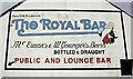
Father William
The painted sign for The Royal Bar in Lockerbie including the portrait of Father William.
Image: © Colin Kinnear
Taken: 6 Jul 2008
0.03 miles
4
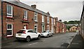
Union Street, Lockerbie
Terraced houses just off the main road through Lockerbie, the B723, Townhead Street.
Image: © Richard Sutcliffe
Taken: 14 Jun 2019
0.04 miles
5
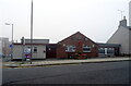
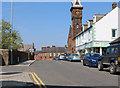
Mid Annandale Comrades Club, Lockerbie
On High Street.
Image: © JThomas
Taken: 15 Sep 2021
0.04 miles
6
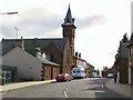
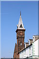
Lockerbie
This imposing building faces the church on the main street through Lockerbie, just north of the town centre.
Image: © Roger May
Taken: 13 Oct 2005
0.04 miles
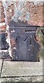
7
Electrical junction box
This old metal cabinet built into the boundary wall of Lockerbie Dryfesdale Church on Townhead Street was presumably a junction box of some kind. It bears the crest of the County Council of Dumfriesshire Electricity Department.
Image: © Richard Sutcliffe
Taken: 14 Jun 2019
0.04 miles
8

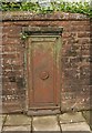
County Council of Dumfriesshire Electricity Department crest
This crest is on the door of an old metal cabinet built into the boundary wall of Lockerbie Dryfesdale Church on Townhead Street [https://www.geograph.org.uk/photo/6182330], which was presumably a junction box of some kind.
Image: © Richard Sutcliffe
Taken: 14 Jun 2019
0.04 miles
9
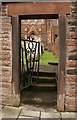
Side gate, Lockerbie Dryfesdale Church
The gateway leads into the churchyard, which contains many 18th century gravestones.
Image: © Richard Sutcliffe
Taken: 14 Jun 2019
0.04 miles
10
Benchmark on building near Dryfesdale Church on west side of Townhead Street
Ordnance Survey cut mark benchmark levelled at 83.731m above Newlyn Datum in 1974
Image: © Roger Templeman
Taken: 24 Oct 2023
0.04 miles