IMAGES TAKEN NEAR TO
Halleaths, LOCKERBIE, DG11 1LS
Introduction
This page details the photographs taken nearby to DG11 1LS by members of the Geograph project.
The Geograph project started in 2005 with the aim of publishing, organising and preserving representative images for every square kilometre of Great Britain, Ireland and the Isle of Man.

There are currently over 7.5m images from over14,400 individuals and you can help contribute to the project by visiting https://www.geograph.org.uk
Image Map
Images are licensed for reuse under creativecommons.org/licenses/by-sa/2.0
Notes
- Clicking on the map will re-center to the selected point.
- The higher the marker number, the further away the image location is from the centre of the postcode.
Image Listing (17 Images Found)
Images are licensed for reuse under creativecommons.org/licenses/by-sa/2.0
Image
Details
Distance
1
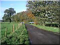
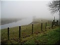
Halleaths
The track serves the tiny hamlet of Halleaths, near Lochmaben. The River Annan is close by, off to the right of the picture. The water in the fields in the middle distance is floodwater, the river having burst its banks after a prolonged spell of torrential rain and gale force winds.
Image: © Lynne Kirton
Taken: 26 Oct 2008
0.05 miles
2
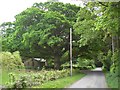
Halleaths Oak Tree
A large oak tree in the hamlet of Halleaths.
Image: © Colin Kinnear
Taken: 21 May 2008
0.06 miles
3
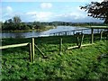
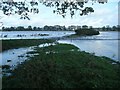
River Annan in flood, Halleaths
The Annan burst its banks after prolonged heavy rain and gale force winds.
Image: © Lynne Kirton
Taken: 26 Oct 2008
0.11 miles
4
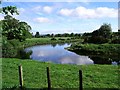
River Annan at Halleaths
A sharp bend in the river at Halleaths, near Lochmaben.
Image: © Lynne Kirton
Taken: 30 May 2005
0.11 miles
5

Fishing the River Annan
Salmon, sea trout and brown trout are among the species caught here.
Image: © Lynne Kirton
Taken: 30 Sep 2006
0.11 miles
6
River Annan at Halleaths, Christmas Day 2007
The weather forecast promised a brighter day with some sunshine, but Christmas Day 2007 was damp, grey and foggy.
Image: © Lynne Kirton
Taken: 25 Dec 2007
0.11 miles
7
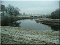
A cold and frosty morning, River Annan
The River Annan at Halleaths. The hard frost had lingered for several days, but it disappeared an hour after the photo was taken.
Image: © Lynne Kirton
Taken: 23 Dec 2007
0.11 miles
8
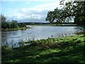
River Annan, Halleaths, in flood
Water levels had begun to drop slightly after the flooding caused by a prolonged spell of torrential rain and gale force winds.
Image: © Lynne Kirton
Taken: 26 Oct 2008
0.12 miles
9
River Annan in flood
The Annan burst its banks after prolonged heavy rain and gale force winds. The footpath on the right bank disappeared underwater, and can just be seen reappearing to the right of the tree in the water in the middle distance, only to disappear again. The track on top of the levée, however, remained clear of the water. Cf. Image
Image: © Lynne Kirton
Taken: 26 Oct 2008
0.15 miles
10
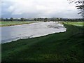
River Annan in flood, Halleaths
The Annan burst its banks after prolonged heavy rain and gale force winds. The normal river channel is on the right of the picture. At some point the water level must have been even higher, since water is flowing back into the river from the flooded field on the left, which is at a higher level than the river itself.
Image: © Lynne Kirton
Taken: 26 Oct 2008
0.15 miles