IMAGES TAKEN NEAR TO
Preston House Road, LOCKERBIE, DG11 1JR
Introduction
This page details the photographs taken nearby to Preston House Road, DG11 1JR by members of the Geograph project.
The Geograph project started in 2005 with the aim of publishing, organising and preserving representative images for every square kilometre of Great Britain, Ireland and the Isle of Man.

There are currently over 7.5m images from over14,400 individuals and you can help contribute to the project by visiting https://www.geograph.org.uk
Image Map
Images are licensed for reuse under creativecommons.org/licenses/by-sa/2.0
Notes
- Clicking on the map will re-center to the selected point.
- The higher the marker number, the further away the image location is from the centre of the postcode.
Image Listing (10 Images Found)
Images are licensed for reuse under creativecommons.org/licenses/by-sa/2.0
Image
Details
Distance
1
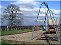
Playground, Hightae
The children's playground on the northern edge of the village of Hightae must be one of the most scenic in the country, looking out over Annandale with beautiful views in all directions.
Image: © Lynne Kirton
Taken: 17 Mar 2008
0.07 miles
2
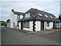
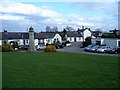
Royal Four Towns Inn, Hightae
Hotel, restaurant and public house in the village of Hightae. The "Royal Four Towns" of Lochmaben are Hightae, Greenhill, Heck and Smallholm.
Image: © Oliver Dixon
Taken: 28 Sep 2007
0.09 miles
3
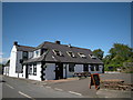
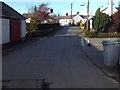
The Hightae Inn
Situated in the village of Hightae - country pub offering home cooked evening meals, en-suite B&B accommodation.
Hightae is one of the historic Royal Four Towns, including Greenhill, Heck and Smallholm, and formed when Robert the Bruce came to the throne and gifted the lands to the inhabitants.
Image: © Mark Cuthbertson
Taken: 4 Jul 2008
0.10 miles
4
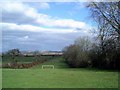
Football pitch, Hightae
Next to the children's playground, on the northern edge of Hightae, is the village football pitch, complete with beautiful views over Annandale.
Image: © Lynne Kirton
Taken: 17 Mar 2008
0.11 miles
5
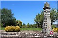
Hightae
The village of Hightae is one of the Royal Four Towns of Lochmaben (planned C18 villages), the others being Greenhill, Heck and Smallholm. Hightae boasts a church, post office, school and pub. The Hightae Church of Scotland Kirk was built as a Relief meeting house and later altered for the Reformed Presbyterians (Cameronians). The Royal Four Towns Hall (1910) has red sandstone dressing with a small statue of Robert the Bruce. The War Memorial (seen in the picture) was erected around 1920.
Image: © Lynne Kirton
Taken: 17 Mar 2008
0.12 miles
8
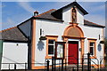
The Royal Four Towns Hall, Hightae
Dated 1910. The Royal Four Towns of Lochmaben - Greenhill, Heck, Hightae and Smallholm.
Image: © Leslie Barrie
Taken: 11 Jun 2015
0.16 miles
9
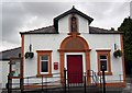
The Royal Four Towns Hall
The town hall in Hightae.
Image: © Colin Kinnear
Taken: 6 Jul 2008
0.20 miles