IMAGES TAKEN NEAR TO
Johnstonebridge, LOCKERBIE, DG11 1ET
Introduction
This page details the photographs taken nearby to DG11 1ET by members of the Geograph project.
The Geograph project started in 2005 with the aim of publishing, organising and preserving representative images for every square kilometre of Great Britain, Ireland and the Isle of Man.

There are currently over 7.5m images from over14,400 individuals and you can help contribute to the project by visiting https://www.geograph.org.uk
Image Map
Images are licensed for reuse under creativecommons.org/licenses/by-sa/2.0
Notes
- Clicking on the map will re-center to the selected point.
- The higher the marker number, the further away the image location is from the centre of the postcode.
Image Listing (7 Images Found)
Images are licensed for reuse under creativecommons.org/licenses/by-sa/2.0
Image
Details
Distance
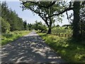
1
B7020 approaching Lochwood Cottage
It seems there are two Lochwood cottages along this road. This one refers to the one south of Riggheads Farm
Image: © John Firth
Taken: 14 May 2014
0.01 miles
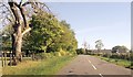
2
B7020, Lockwood
A long straight road, aligned with the long hills on either side.
Image: © Richard Webb
Taken: 17 Aug 2015
0.08 miles
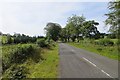
3
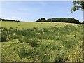
Field, Lockwood
The landscape here is one of long parallel hills, aligned north to south. There is a gap in the woodlands which normally accompany the B7020.
Image: © Richard Webb
Taken: 17 Aug 2015
0.08 miles
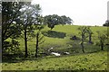
4
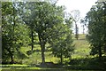
Woodland, Beastock Rig
Scattered oaks, probably left after felling other trees.
Image: © Richard Webb
Taken: 17 Aug 2015
0.11 miles
6
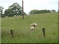
Field near Riggheads
Seen from the B7020
Image: © Richard Webb
Taken: 31 Jul 2024
0.16 miles