IMAGES TAKEN NEAR TO
Merlin Way, ILKESTON, DE7 4RA
Introduction
This page details the photographs taken nearby to Merlin Way, DE7 4RA by members of the Geograph project.
The Geograph project started in 2005 with the aim of publishing, organising and preserving representative images for every square kilometre of Great Britain, Ireland and the Isle of Man.

There are currently over 7.5m images from over14,400 individuals and you can help contribute to the project by visiting https://www.geograph.org.uk
Image Map
Images are licensed for reuse under creativecommons.org/licenses/by-sa/2.0
Notes
- Clicking on the map will re-center to the selected point.
- The higher the marker number, the further away the image location is from the centre of the postcode.
Image Listing (22 Images Found)
Images are licensed for reuse under creativecommons.org/licenses/by-sa/2.0
Image
Details
Distance
1
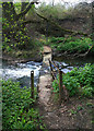
Pedestrian crossing over the Nut Brook
This metal footbridge used to link one side of the vast Stanton Ironworks site to the other. It has collapsed in centre stream causing the water to back up behind debris caught in its structure.
Image: © Kate Jewell
Taken: 22 Apr 2008
0.16 miles
2
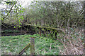
Old footbridge over the Nut Brook
More industrial detritus left over from the heyday of the Stanton Ironworks. The walkway between the railings has all but collapsed but the pipe that is attached to the structure looks remarkably sound.
Image: © Kate Jewell
Taken: 22 Apr 2008
0.16 miles
3

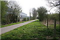
Merlin Way
This is the main route through the Quarry Hill Industrial Estate which was built on the old Stanton Ironworks site. Photograph taken from the north east entrance to the Stanton North Lagoons Conservation Area.
Image: © Kate Jewell
Taken: 22 Apr 2008
0.16 miles
4
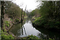
The Nut Brook
Looking down stream. The Nutbrook Trail is behind the trees on the left.
Image: © Kate Jewell
Taken: 22 Apr 2008
0.17 miles
5
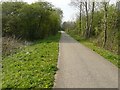
The Nutbrook Trail
Looking towards Long Eaton. This cycleway and Long Distance Path extends 9 miles between Long Eaton and Shipley Country Park. This stretch that follows a dismantled railway passes between the old Stanton Ironwork site on the right and the Quarry Hill Industrial Estate on the left.
Image: © Kate Jewell
Taken: 22 Apr 2008
0.17 miles
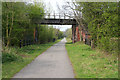
6
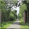
Nutbrook Trail near Hallam Fields
Passing by a pair of old railway bridge pylons.
Image: © David Lally
Taken: 16 Jun 2018
0.18 miles
7
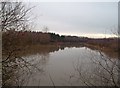
Lagoon near the Nutbrook Trail
A look at the current map indicates that the disused Nutbrook Canal canal ran to the left of this lake while the Nutbrook trail (and cycleway) follows the course of a disused railway line to the right.
Image: © Jonathan Clitheroe
Taken: 4 Jan 2014
0.18 miles
9
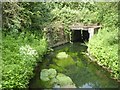
Old railway bridge over the Nutbrook Trail
The Nutbrook Trail follows the route of the dismantled Stanton railway branch line. The track that this bridge carried over the branch line used to link one side of the old Stanton Ironworks to the other. The namesake of the trail, the Nut Brook, is culverted under the footpath at this point.
Image: © Kate Jewell
Taken: 22 Apr 2008
0.19 miles