IMAGES TAKEN NEAR TO
Birdcroft Lane, ILKESTON, DE7 4BE
Introduction
This page details the photographs taken nearby to Birdcroft Lane, DE7 4BE by members of the Geograph project.
The Geograph project started in 2005 with the aim of publishing, organising and preserving representative images for every square kilometre of Great Britain, Ireland and the Isle of Man.

There are currently over 7.5m images from over14,400 individuals and you can help contribute to the project by visiting https://www.geograph.org.uk
Image Map
Images are licensed for reuse under creativecommons.org/licenses/by-sa/2.0
Notes
- Clicking on the map will re-center to the selected point.
- The higher the marker number, the further away the image location is from the centre of the postcode.
Image Listing (20 Images Found)
Images are licensed for reuse under creativecommons.org/licenses/by-sa/2.0
Image
Details
Distance
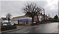
1
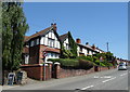
Houses on Little Hallam Hill, Little Hallam, Ilkeston
Image: © JThomas
Taken: 29 Jun 2019
0.09 miles
2
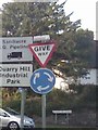
UK Give Way And Mini Roundabout Sign
UK Give Way And Mini Roundabout Sign On Little Hallam Hill Ilkeston Derbyshire.
Image: © gary
Taken: 26 Jun 2015
0.09 miles
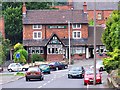
3
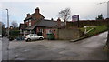
Bull's Head, Little Hallam Hill
Pub at the south end of Ilkeston.
Image: © Peter Barr
Taken: 8 Dec 2014
0.10 miles
4
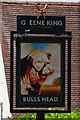
Sign for the Bulls Head, Little Hallam, Ilkeston
Image: © JThomas
Taken: 29 Jun 2019
0.10 miles
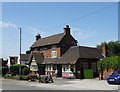
5
Bulls Head, Ilkeston
The Bulls Head on Little Hallam Hill is thought to be one of the oldest pubs in the area and its appearance has changed little over the years.
Image: © Garth Newton
Taken: 14 Jul 2004
0.10 miles
6
The Bulls Head, Little Hallam, Ilkeston
On Little Hallam Hill.
Image: © JThomas
Taken: 29 Jun 2019
0.11 miles
7
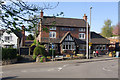
Bulls Head, Little Hallam
This pub stands in a prominent position on Little Hallam Hill between Ilkeston and Kirk Hallam. Compare this view with a similar one taken five years earlier Image - sadly the 'Kimberley Ales' sign, once ubiquitous in this area, has gone.
Image: © Stephen McKay
Taken: 18 Apr 2009
0.11 miles
8

Inscribed cornice stone
On Image presumably refers to a branch number of the local Cooperative Society.
Image: © David Lally
Taken: 1 Apr 2013
0.12 miles
9
Co-op Funeral Directors
On the corner of Lower Stanton Road and Catherine Avenue.
By the architecture I assume this was built as a Co-op shop (branch No. 14 it would seem). I got chatting to a local who said it had been occupied quite a few different businesses before becoming this branch of the Co-op funeral directors.
Image: © David Lally
Taken: 1 Apr 2013
0.12 miles
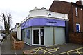
10
Co-operative Funeral Care
Undertakers' premises, in Co-op Branch No. 14.
Image: © Peter Barr
Taken: 8 Dec 2014
0.12 miles