IMAGES TAKEN NEAR TO
Long Acre, DERBY, DE74 2UH
Introduction
This page details the photographs taken nearby to Long Acre, DE74 2UH by members of the Geograph project.
The Geograph project started in 2005 with the aim of publishing, organising and preserving representative images for every square kilometre of Great Britain, Ireland and the Isle of Man.

There are currently over 7.5m images from over14,400 individuals and you can help contribute to the project by visiting https://www.geograph.org.uk
Image Map
Images are licensed for reuse under creativecommons.org/licenses/by-sa/2.0
Notes
- Clicking on the map will re-center to the selected point.
- The higher the marker number, the further away the image location is from the centre of the postcode.
Image Listing (10 Images Found)
Images are licensed for reuse under creativecommons.org/licenses/by-sa/2.0
Image
Details
Distance
1
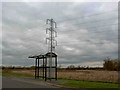
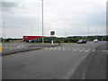
Bus shelter on Broad Rushes
To service the adjacent Willow Farm business park.
Image: © Steve Fareham
Taken: 30 Mar 2009
0.10 miles
2
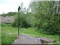
Footpath to Back Lane
The sign and steps were added when the path was cut by Broad Rushes.
Image: © Ian Calderwood
Taken: 11 May 2015
0.13 miles
6
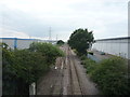
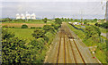
Railway heading west
From the bridge on Station Road.
Image: © JThomas
Taken: 21 Jul 2016
0.18 miles
7
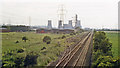
Westward from the bridge at Castle Donington & Shardlow
View towards Stenson Junction and Burton-on-Trent: ex-Midland Trent (Sheet Stores Junction) - Stenson Junction (Burton-on-Trent) loop line. In the distance is Castle Donington Power Station, which closed eventually in 1994. (See also Image]).
Image: © Ben Brooksbank
Taken: 7 Jun 1988
0.19 miles
8
Site of Castle Donington & Shardlow station, 1988
View eastward, towards Sheet Stores Junction, Trent: ex-Midland Trent - Stenson Junction - Burton-on-Trent relief line. The station was closed to passengers from 22/9/30, to goods from 1/5/67, but the line remains open for through freight (especially coal) towards Birmingham to by-pass Derby. The Power Station in the distance is Ratcliffe on Soar.
Image: © Ben Brooksbank
Taken: 7 Jun 1988
0.19 miles
9
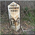
Old Milepost by Station Road in Castle Donington
Cast iron post by the UC road (was A453), in parish of Castle Donington (North West Leicestershire District), Station Road; South of railway bridge embankment, on the verge, on East side of road. Wootton iron casting, erected by the Tamworth to Harrington Bridge turnpike trust in the 19th century.
Inscription reads:-
: TAMWORTH / 23 / MILES : : CASTLE / DONNINGTON / PARISH : : NOTTINGHAM / 12 / MILES :
Maker:-
: WOOTTON BROS / IRON WORKS / COALVILLE :
Grade II listed.
List Entry Number: 1361340 https://historicengland.org.uk/listing/the-list/list-entry/1361340
Milestone Society National ID: LE_TMNT23
Image: © Alan Rosevear
Taken: 22 Mar 2016
0.22 miles