IMAGES TAKEN NEAR TO
Ingleby Road, DERBY, DE73 7HT
Introduction
This page details the photographs taken nearby to Ingleby Road, DE73 7HT by members of the Geograph project.
The Geograph project started in 2005 with the aim of publishing, organising and preserving representative images for every square kilometre of Great Britain, Ireland and the Isle of Man.

There are currently over 7.5m images from over14,400 individuals and you can help contribute to the project by visiting https://www.geograph.org.uk
Image Map
Images are licensed for reuse under creativecommons.org/licenses/by-sa/2.0
Notes
- Clicking on the map will re-center to the selected point.
- The higher the marker number, the further away the image location is from the centre of the postcode.
Image Listing (34 Images Found)
Images are licensed for reuse under creativecommons.org/licenses/by-sa/2.0
Image
Details
Distance
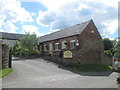
1
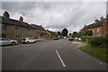
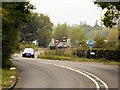
Stanton by Bridge
The small village of Stanton by Bridge gets its name from being close to the southern end of Swarkestone Causeway.
Image: © Malcolm Neal
Taken: 7 Aug 2017
0.04 miles
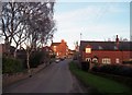
2
Stanton by Bridge, Jubilee Oak
As its name suggests Stanton by Bridge is located next to a major bridge; the village is at the southern end of the ancient Swarkestone Bridge (Causeway) that carries the main A514 road over the River Trent and its flood plain.
The village green contains an oak tree planted to commemorate the Diamond Jubilee of Queen Victoria (1897).
Image: © David Dixon
Taken: 20 Sep 2014
0.05 miles
4
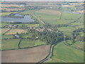
Stanton by Bridge
Seen looking north from above Melbourne, on approach to Runway 09 at East Midlands Airport. The A514, carried by the mile-long 13C Swarkestone Bridge causeway, can be seen heading away from the village in the upper part of the picture.
Image: © M J Richardson
Taken: 9 Oct 2012
0.08 miles
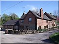
6
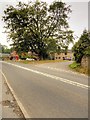
Stanton by Bridge Village Scene
Pictured here at dusk on a fine March day.
Image: © Jonathan Clitheroe
Taken: 4 Mar 2014
0.11 miles
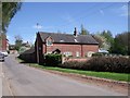
8
Hollow Farm
According to the Consarvation Area History published by South Derbyshire District Council, Hollow Farm used to be an inn kept by the Rolleston family until 1802.
Image: © Ian Calderwood
Taken: 6 May 2013
0.13 miles
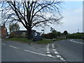
9
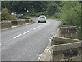
A514 at the End of Swarkestone Causeway
Swarkestone Bridge and Causeway, at a length of three quarters of a mile, is the longest stone bridge in England and holds Grade I listed building status (English Heritage Building ID: 83210 http://www.britishlistedbuildings.co.uk/en-83210-swarkestone-bridge-and-causeway-stanton-b British Listed Buildings) as well as being a scheduled ancient monument. It is still today an important crossing place over the River Trent.
The mediæval causeway, widened and strengthened in the eighteenth and nineteenth centuries, dates originally from the 13th century. Although the bridge and causeway are undersized for modern traffic and there is a weight limit of 7.5 tonnes, they remain heavily used today as a vital link on the A514 from Derby to the southern part of the County, connecting with the nearby network of motorways.
Image: © David Dixon
Taken: 20 Sep 2014
0.13 miles
10
Swarkestone Causeway - south end
The tops of the cutwaters provide useful pedestrian refuges at this end; for most of its length there aren't any refuges, and little or nothing in the way of a footway so doing the whole length on foot would be an interesting prospect, given the amount of traffic.
Image: © Alan Murray-Rust
Taken: 7 Sep 2008
0.15 miles