IMAGES TAKEN NEAR TO
Sawley Road, DERBY, DE72 3QF
Introduction
This page details the photographs taken nearby to Sawley Road, DE72 3QF by members of the Geograph project.
The Geograph project started in 2005 with the aim of publishing, organising and preserving representative images for every square kilometre of Great Britain, Ireland and the Isle of Man.

There are currently over 7.5m images from over14,400 individuals and you can help contribute to the project by visiting https://www.geograph.org.uk
Image Map
Images are licensed for reuse under creativecommons.org/licenses/by-sa/2.0
Notes
- Clicking on the map will re-center to the selected point.
- The higher the marker number, the further away the image location is from the centre of the postcode.
Image Listing (18 Images Found)
Images are licensed for reuse under creativecommons.org/licenses/by-sa/2.0
Image
Details
Distance
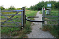
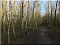
1
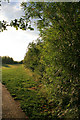
Inside Orchid Wood
On my list of tree species here Image I forgot to mention Willow - here's one on the right!
Image: © David Lally
Taken: 2 Jul 2008
0.07 miles
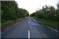
2

Sawley Road
Looking Northwest toward Draycott.
This might look straight enough to be the course of a Roman Road, but it is in fact a modern replacement for one; Draycott Road, Sawley / Sawley Road Draycott did follow a roman route, but that is now submerged beneath the Wilne reservoirs.
Image: © David Lally
Taken: 2 Jul 2008
0.07 miles
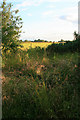
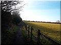
4
Footpath at Wilne Cross
Looking NE across fields towards Church Wilne reservoir. This bridleway is well used and forms part of a local circular walk.
Image: © Peter Shone
Taken: 13 Oct 2005
0.08 miles
5
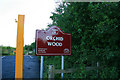
Sign for Orchid Wood
In that delightful shade I like to call Erewash Maroon.
Image: © David Lally
Taken: 2 Jul 2008
0.10 miles
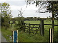
6
Entry to Orchid Wood
From the small car park adjacent to Sawley Road, Draycott.
Quite recently planted by the borough, Orchid Wood is a mixed plantation of Alder, Birch, Lime, Oak, and Hawthorn (to name the ones I spotted this evening) with a few conifers thrown-in.
Toward the South Western edge there are some large gorse bushes, which may predate the planting, they certainly appear older than the trees.
Image: © David Lally
Taken: 2 Jul 2008
0.11 miles
8
Coffin Walk near Wilne Cross
Bridleway and former funeral procession route between Church Wilne and Breaston, the latter village having had to wait until 1824 to acquire its own church for burials. Paths which served this historical purpose also exist elsewhere in Derbyshire - for example here http://www.geograph.org.uk/photo/1733353 between Castleton and Edale and here http://www.geograph.org.uk/photo/936936 between Lullington and Coton-in-the-Elms.
Image: © Jonathan Clitheroe
Taken: 29 Dec 2013
0.13 miles
9
Sawley Road
Looking Southeast toward Sawley.
This might look straight enough to be the course of a Roman Road, but it is in fact a modern replacement for one; Draycott Road, Sawley / Sawley Road Draycott did follow a roman route, but that is now submerged beneath the Wilne reservoirs.
Image: © David Lally
Taken: 2 Jul 2008
0.13 miles
10
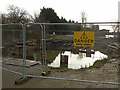
Danger Deep water
The works appear to be related to the Derwent Aqueduct which feeds into Church Wilne Reservoir. The water has presumably filled the hole as a result of inactivity over the Christmas and New Year holiday period.
Image: © Alan Murray-Rust
Taken: 1 Jan 2018
0.17 miles