IMAGES TAKEN NEAR TO
Hopwell Road, DERBY, DE72 3PE
Introduction
This page details the photographs taken nearby to Hopwell Road, DE72 3PE by members of the Geograph project.
The Geograph project started in 2005 with the aim of publishing, organising and preserving representative images for every square kilometre of Great Britain, Ireland and the Isle of Man.

There are currently over 7.5m images from over14,400 individuals and you can help contribute to the project by visiting https://www.geograph.org.uk
Image Map
Images are licensed for reuse under creativecommons.org/licenses/by-sa/2.0
Notes
- Clicking on the map will re-center to the selected point.
- The higher the marker number, the further away the image location is from the centre of the postcode.
Image Listing (13 Images Found)
Images are licensed for reuse under creativecommons.org/licenses/by-sa/2.0
Image
Details
Distance
1

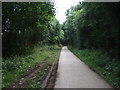
A Stand of Pines near Draycott
The path I am on leads from Hopwell Road to Nottingham Road, Borrowash.
Image: © David Lally
Taken: 3 May 2009
0.07 miles
2
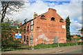
Derelict building on Hopwell Road
The condition of this building has only deteriorated since Mike Bardill photographed it in 2006. Its function was probably related in some way to the Derby and Sandiacre Canal which ran next to it.
Image: © David Lally
Taken: 3 May 2009
0.08 miles
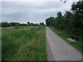
4

Path and Former Canal Route near Hopwell Road
Path and cycleway approaching Hopwell Road with Draycott Fields Farm visible straight ahead. This is the course of the former Derby and Sandiacre Canal.
Image: © Jonathan Clitheroe
Taken: 29 Dec 2013
0.11 miles
5
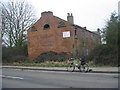
Derby and Sandiacre Canal - Draycott
These derelict buildings stand next to the Derby and Sandiacre Canal at Draycott. The canal was filled in along this part of the route but it has recently been dug out as part of a flood alleviation scheme for the nearby railway line.
Image: © Mike Bardill
Taken: 5 Feb 2006
0.12 miles
8
Cycle Route 6 following the former Derby canal
There are ambitious plans to restore the canal http://www.bbc.co.uk/news/uk-england-derbyshire-14076943
Image: © Tim Heaton
Taken: 2 Sep 2012
0.17 miles
9
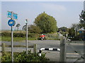
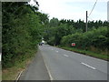
National Cycle route 6 crosses Hopewell Rd near Draycott
National cycle route 6 is a Sustrans route that runs from London in the South up through the Midlands via Leicester, Nottingham and Derby before heading through the Peak District and on to the Northwest via Manchester and Preston, then up through the Lake District to end near Carlisle. Here is crosses Hopewell Rd near Draycott Derbyshire as it follows the path of the disused Derby Canal.
Image: © Peter Shone
Taken: 16 Oct 2005
0.18 miles
10
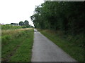
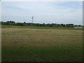
Cycle track, Draycott Fields
Heading east.
Image: © JThomas
Taken: 27 Jul 2013
0.19 miles