IMAGES TAKEN NEAR TO
Common Piece Lane, DERBY, DE65 6AF
Introduction
This page details the photographs taken nearby to Common Piece Lane, DE65 6AF by members of the Geograph project.
The Geograph project started in 2005 with the aim of publishing, organising and preserving representative images for every square kilometre of Great Britain, Ireland and the Isle of Man.

There are currently over 7.5m images from over14,400 individuals and you can help contribute to the project by visiting https://www.geograph.org.uk
Image Map
Images are licensed for reuse under creativecommons.org/licenses/by-sa/2.0
Notes
- Clicking on the map will re-center to the selected point.
- The higher the marker number, the further away the image location is from the centre of the postcode.
Image Listing (66 Images Found)
Images are licensed for reuse under creativecommons.org/licenses/by-sa/2.0
Image
Details
Distance
2
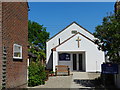
Findern Methodist Chapel
Compare this to Image taken about 3 years earlier.
The Methodist congregation had a vision that they were called to be “.... an expression of our loving, giving God, enabling others to find inner peace through Jesus Christ”.
To make this become a reality they set about transforming the church building.
Each Wednesday afternoon coffee and cake are offered to anyone passing by. Except if you call in on the first Wednesday of the month as that's Lunch Club! Unfortunately it was a Tuesday when I was in the village!
Image: © Kate Jewell
Taken: 25 May 2010
0.02 miles
3
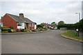
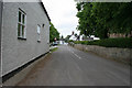
Sycamore Avenue, Findern
Newish housing on the edge of the village.
Image: © Kate Jewell
Taken: 25 May 2010
0.02 miles
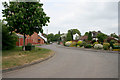
4
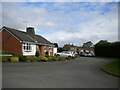
Sycamore Avenue, Findern
A residential cul de sac off Common Piece Lane, at the eastern edge of the village.
Image: © Richard Vince
Taken: 29 Aug 2020
0.03 miles
5
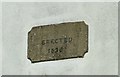
Datestone on the Methodist Chapel
Dated 1835, see http://www.geograph.org.uk/photo/5595323 for location.
Image: © Alan Murray-Rust
Taken: 5 Nov 2017
0.03 miles
6
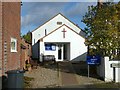
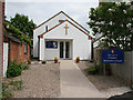
Findern Methodist Chapel
Chapel of 1835 http://www.geograph.org.uk/photo/5595322 with 21st century extension. Note the continuing use of the word 'Chapel' whereas most congregations now use 'Church' even when the building can be thought of as a chapel.
Image: © Alan Murray-Rust
Taken: 5 Nov 2017
0.03 miles
7
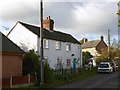
Ivy Cottage, Common Piece Lane
Rather plain, but reputedly the oldest house in the village, dating in part from the 17th century, but clearly much modified over time. It was a weaver's cottage.
Image: © Alan Murray-Rust
Taken: 5 Nov 2017
0.03 miles
8
Lower Green by the church
Looking north up Lower Green towards http://www.geograph.org.uk/photo/1907699
Image: © Kate Jewell
Taken: 25 May 2010
0.03 miles
10
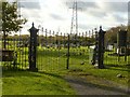
Findern Cemetery
The fine cast iron gateposts suggest a Victorian origin, but it was not created until about the 1950s.
Image: © Alan Murray-Rust
Taken: 5 Nov 2017
0.04 miles