IMAGES TAKEN NEAR TO
Derby Road, ASHBOURNE, DE6 1BE
Introduction
This page details the photographs taken nearby to Derby Road, DE6 1BE by members of the Geograph project.
The Geograph project started in 2005 with the aim of publishing, organising and preserving representative images for every square kilometre of Great Britain, Ireland and the Isle of Man.

There are currently over 7.5m images from over14,400 individuals and you can help contribute to the project by visiting https://www.geograph.org.uk
Image Map
Images are licensed for reuse under creativecommons.org/licenses/by-sa/2.0
Notes
- Clicking on the map will re-center to the selected point.
- The higher the marker number, the further away the image location is from the centre of the postcode.
Image Listing (120 Images Found)
Images are licensed for reuse under creativecommons.org/licenses/by-sa/2.0
Image
Details
Distance
1
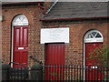
Ashbourne - Coopers Almshouses Plaque
See Image for view of the building to which the plaque relates.
Image: © Dave Bevis
Taken: 29 Apr 2010
0.01 miles
2
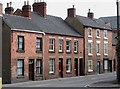
Ashbourne - The Chantry and Coopers Almshouses
Image: © Dave Bevis
Taken: 29 Apr 2010
0.02 miles
3
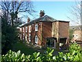
Walton Bank, Derby Road, Ashbourne
Late 18th century house, traditionally believed to have been used as a prison for General Rochambeau and other French soldiers in the Napoleonic wars. Listed Grade II.
Image: © Alan Murray-Rust
Taken: 6 Mar 2017
0.03 miles
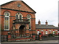
4
Former Sion Chapel and school, and Cooper's Almshouses, Derby Road, Ashbourne
The chapel dates to around 1800, although the frontage is a later 19th century remodelling. It was endowed by John Cooper who also endowed the almshouses below the chapel. Both chapel and almshouses are Listed Grade II. The Sion Chapel was an Independent congregation linked to the Countess of Huntingdon's Connexion and eventually joined the United Reformed Church in the late 1970s.
The nearer building, probably built around 1900, houses a former Sunday school and dwelling for the minister, now a nursery.
Image: © Alan Murray-Rust
Taken: 6 Mar 2017
0.03 miles
6
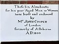
Almshouses inscription
See http://www.geograph.org.uk/photo/1836450 for location.
Image: © Alan Murray-Rust
Taken: 6 Mar 2017
0.04 miles
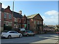
8

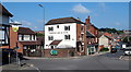
The bottom of Derby Hill
The visible road junction has 5 roads leading to it all controlled by traffic lights so congestion is not too bad.
Image: © Malcolm Neal
Taken: 15 Apr 2017
0.04 miles
9
Compton Area, Ashbourne, Derbys.
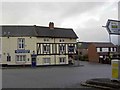
A busy junction on the south side of the town. This is the point where Old Hill (behind the photographer) approaches the town centre. Station Street (the A515) can be seen on the left, disappearing behind the side of the former Plough Inn. Compton Street (also the A515)- straight ahead - leads to the town centre, whilst Sturston Road (the A517) branches off to the right. Catherine Booth, nee Mumford, who married William Booth, the Salvation Army founder, lived at No.13, Sturston Road. The original town of Ashbourne was always to the north of the Henmore Brook that crosses Compton Street. Compton was a separate village with its own market and it was not until 1873 that Compton came under the jurisdiction of Ashbourne.
Image: © David Hallam-Jones
Taken: 26 Aug 2013
0.05 miles
10
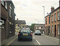
Derby road Sturston Road junction
From Sturston Road
Image: © John Firth
Taken: 13 Jul 2011
0.06 miles