IMAGES TAKEN NEAR TO
Farley, MATLOCK, DE4 5LQ
Introduction
This page details the photographs taken nearby to DE4 5LQ by members of the Geograph project.
The Geograph project started in 2005 with the aim of publishing, organising and preserving representative images for every square kilometre of Great Britain, Ireland and the Isle of Man.

There are currently over 7.5m images from over14,400 individuals and you can help contribute to the project by visiting https://www.geograph.org.uk
Image Map
Images are licensed for reuse under creativecommons.org/licenses/by-sa/2.0
Notes
- Clicking on the map will re-center to the selected point.
- The higher the marker number, the further away the image location is from the centre of the postcode.
Image Listing (10 Images Found)
Images are licensed for reuse under creativecommons.org/licenses/by-sa/2.0
Image
Details
Distance
1
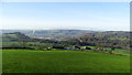
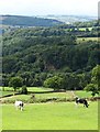
View to Darley Dale from Farley Lane above Tax Farm
Image: © Colin Park
Taken: 17 Dec 2018
0.03 miles
3
Tax Farm
This track leads to Tax Farm. I assume this is where the Treasury produce new taxes?
Image: © Michael Patterson
Taken: 5 Oct 2006
0.09 miles
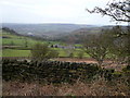
4
Above Tax Farm
With a view to The Derwent Valley
Image: © Neil Theasby
Taken: 1 Aug 2015
0.12 miles
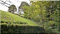
5
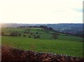
Arable Grassland near Upper Hackney
This picture was taken from Farley Lane near the entrance to Tax Farm.
Image: © Jonathan Clitheroe
Taken: 10 Dec 2011
0.14 miles
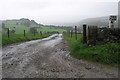
6
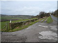
Farley Lane,Tax Farm and Tax Cottage Access Roads Meet
Image: © Alan Heardman
Taken: 13 Feb 2007
0.14 miles
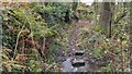
7
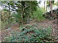
Footpath and track junction in Holt Wood
The footpath on the left continues to Sydnop Brook. The track to the right goes to Trax Farm but appears to be rarely used.
Image: © Graham Hogg
Taken: 20 Oct 2014
0.17 miles
8
The map shows a track down here
But no wheeled traffic has passed through for many years, and few two legged travellers can have done either!
Image: © Chris Morgan
Taken: 20 Oct 2014
0.17 miles
9
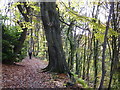
Autumn leaves on a path above Potter Dam
Old woodland; a track which once will have been the access to a stone quarry and to the top of Potter Dam.
Image: © Peter Barr
Taken: 30 Oct 2012
0.24 miles