IMAGES TAKEN NEAR TO
Steep Turnpike, MATLOCK, DE4 3DP
Introduction
This page details the photographs taken nearby to Steep Turnpike, DE4 3DP by members of the Geograph project.
The Geograph project started in 2005 with the aim of publishing, organising and preserving representative images for every square kilometre of Great Britain, Ireland and the Isle of Man.

There are currently over 7.5m images from over14,400 individuals and you can help contribute to the project by visiting https://www.geograph.org.uk
Image Map
Images are licensed for reuse under creativecommons.org/licenses/by-sa/2.0
Notes
- Clicking on the map will re-center to the selected point.
- The higher the marker number, the further away the image location is from the centre of the postcode.
Image Listing (157 Images Found)
Images are licensed for reuse under creativecommons.org/licenses/by-sa/2.0
Image
Details
Distance
1
Stile and steps to footpath to Denefields
The picture is taken from Steep Turnpike in Matlock. As you can see there are six steps up directly through the stile. The path takes you through to Denesfield an open space not far from the middle of town.
Image: © Tim Hodgins
Taken: 9 Aug 2018
0.03 miles
2
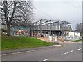
New fire station under construction
The 1950s fire station, pictured in Image, has been demolished, to be replaced by something more modern.
Image: © Ian Calderwood
Taken: 29 Dec 2023
0.10 miles
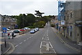
3

Matlock fire station
Matlock fire station, Matlock Road, Matlock, Derbyshire
Image: © Kevin Hale
Taken: 4 Aug 2010
0.11 miles
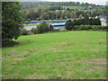
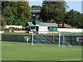
7
Matlock Town football ground
Looking across to the Twigg Stand.
Image: © David Martin
Taken: 6 Apr 2014
0.12 miles
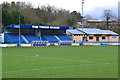
8
The Pavilion, Matlock Cricket Club
As seen on matchday from the ground of Matlock Town FC.
Image: © Stuart Shepherd
Taken: 27 Sep 2009
0.13 miles
10
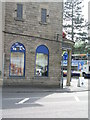
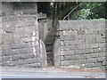
Side view of Maazi Restaurant, Matlock
The side viewed from the road called Steep Turnpike. A cut bench mark (see http://www.geograph.org.uk/photo/2554842 ) is on the wall close to the post for the roundabout sign.
Image: © Brian Westlake
Taken: 5 May 2011
0.14 miles