IMAGES TAKEN NEAR TO
Merevale Way, DERBY, DE24 3BR
Introduction
This page details the photographs taken nearby to Merevale Way, DE24 3BR by members of the Geograph project.
The Geograph project started in 2005 with the aim of publishing, organising and preserving representative images for every square kilometre of Great Britain, Ireland and the Isle of Man.

There are currently over 7.5m images from over14,400 individuals and you can help contribute to the project by visiting https://www.geograph.org.uk
Image Map
Images are licensed for reuse under creativecommons.org/licenses/by-sa/2.0
Notes
- Clicking on the map will re-center to the selected point.
- The higher the marker number, the further away the image location is from the centre of the postcode.
Image Listing (14 Images Found)
Images are licensed for reuse under creativecommons.org/licenses/by-sa/2.0
Image
Details
Distance
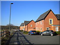
1
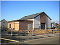
Community centre, Chartley Road, Stenson Fields
Under construction when this photograph was taken.
Image: © Richard Vince
Taken: 2 Feb 2019
0.06 miles
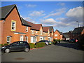
2
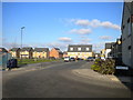
Merevale Way, Stenson Fields
Bending north at the junction with Chartley Road.
Image: © Richard Vince
Taken: 2 Feb 2019
0.07 miles
3
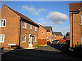
Orchid Court, Stenson Fields
A cul de sac off Baneberry Way.
Image: © Richard Vince
Taken: 2 Feb 2019
0.08 miles
4
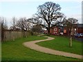
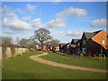
Perimeter path
The path around the recently-built estate snakes its way between the houses and the railway and between new and established trees.
Image: © Ian Calderwood
Taken: 19 Dec 2017
0.14 miles
5
Western corner of Stenson Fields
This footpath threads its way between the easternmost houses and the Derby to Birmingham railway line (just beyond the fence to the left).
Image: © Richard Vince
Taken: 2 Feb 2019
0.15 miles
6
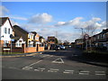
South west end of Pilgrims Way, Stenson Fields
Seen from Stenson Road.
Image: © Richard Vince
Taken: 2 Feb 2019
0.15 miles
7
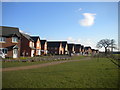
South western edge of Stenson Fields (1)
Where the housing estate meets the actual fields.
Image: © Richard Vince
Taken: 2 Feb 2019
0.15 miles
8
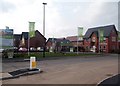
New Housing Development in Stenson Fields
This new estate on green field land has been christened Newton Village. The show property and sales office can be seen here at the entrance to the development.
Image: © Jonathan Clitheroe
Taken: 8 Mar 2014
0.17 miles
9
Mallow Close, Stenson Fields
Seen from the service road along the edge of the estate.
Image: © Richard Vince
Taken: 2 Feb 2019
0.17 miles
10
South western edge of Stenson Fields (2)
Bounded by a service road.
Image: © Richard Vince
Taken: 2 Feb 2019
0.18 miles