IMAGES TAKEN NEAR TO
Stenson Road, DERBY, DE23 1JN
Introduction
This page details the photographs taken nearby to Stenson Road, DE23 1JN by members of the Geograph project.
The Geograph project started in 2005 with the aim of publishing, organising and preserving representative images for every square kilometre of Great Britain, Ireland and the Isle of Man.

There are currently over 7.5m images from over14,400 individuals and you can help contribute to the project by visiting https://www.geograph.org.uk
Image Map
Images are licensed for reuse under creativecommons.org/licenses/by-sa/2.0
Notes
- Clicking on the map will re-center to the selected point.
- The higher the marker number, the further away the image location is from the centre of the postcode.
Image Listing (24 Images Found)
Images are licensed for reuse under creativecommons.org/licenses/by-sa/2.0
Image
Details
Distance
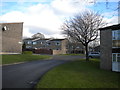
1
Leading to Peggs Walk, Sunnyhill
A cul de sac off Caxton Street.
Image: © Richard Vince
Taken: 2 Feb 2019
0.06 miles
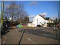
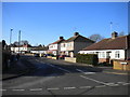
2
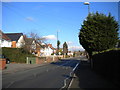
Stenson Road, Sunnyhill (1)
Looking towards Normanton and Derby city centre.
Image: © Richard Vince
Taken: 2 Feb 2019
0.07 miles
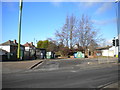
3
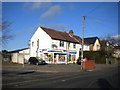
Convenience shop, Stenson Road, Sunnyhill
Image: © Richard Vince
Taken: 2 Feb 2019
0.08 miles
4
Caxton Street, Sunnyhill (2)
This side of the road lacks a pavement, for some reason.
Image: © Richard Vince
Taken: 2 Feb 2019
0.08 miles
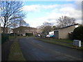
5
Former bus turning circle, Stenson Road, Sunnyhill (2)
Still containing a bus stop, which is visited by buses on Arriva Derby route 7 as they travel from Sinfin to Derby city centre.
Image: © Richard Vince
Taken: 2 Feb 2019
0.09 miles
6
Former bus turning circle, Stenson Road, Sunnyhill (1)
Still containing a bus stop, which is visited by buses on Arriva Derby route 7 as they travel from Sinfin to Derby city centre.
Image: © Richard Vince
Taken: 2 Feb 2019
0.10 miles
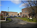
8
East end of Nevinson Drive, Sunnyhill
Seen from Wellesley Avenue, of which Nevinson Drive is effectively an extension.
Image: © Richard Vince
Taken: 2 Feb 2019
0.11 miles
9
East end of Nevinson Avenue, Sunnyhill
Seen from Wellesley Avenue.
Image: © Richard Vince
Taken: 2 Feb 2019
0.11 miles
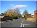
10
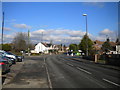
Stenson Road, Sunnyhill (2)
Looking towards Derby city centre from the end of Brookfield Avenue.
Image: © Richard Vince
Taken: 2 Feb 2019
0.13 miles