IMAGES TAKEN NEAR TO
Wyaston Close, DERBY, DE22 2XG
Introduction
This page details the photographs taken nearby to Wyaston Close, DE22 2XG by members of the Geograph project.
The Geograph project started in 2005 with the aim of publishing, organising and preserving representative images for every square kilometre of Great Britain, Ireland and the Isle of Man.

There are currently over 7.5m images from over14,400 individuals and you can help contribute to the project by visiting https://www.geograph.org.uk
Image Map
Images are licensed for reuse under creativecommons.org/licenses/by-sa/2.0
Notes
- Clicking on the map will re-center to the selected point.
- The higher the marker number, the further away the image location is from the centre of the postcode.
Image Listing (4 Images Found)
Images are licensed for reuse under creativecommons.org/licenses/by-sa/2.0
Image
Details
Distance
1
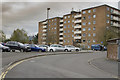
Park Farm flats and car park
These flats have been here for around 60 years give or take a few. The car park edge we can see is for the Park Farm Shopping Centre.
Image: © Malcolm Neal
Taken: 13 Apr 2017
0.16 miles
2
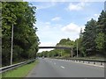
Footbridge over A38 Queensway
Linking housing estates on the left and a school on the right
Image: © David Smith
Taken: 26 Aug 2017
0.18 miles
3
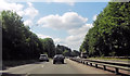
Markeaton Golf Course
Has not been a golf course for a long time. Now a housing estate. The path with the no cycling sign used to pass a trig point. Long since demolished.
Image: © Richard Webb
Taken: 22 Feb 2004
0.20 miles