IMAGES TAKEN NEAR TO
Birchover Way, DERBY, DE22 2QL
Introduction
This page details the photographs taken nearby to Birchover Way, DE22 2QL by members of the Geograph project.
The Geograph project started in 2005 with the aim of publishing, organising and preserving representative images for every square kilometre of Great Britain, Ireland and the Isle of Man.

There are currently over 7.5m images from over14,400 individuals and you can help contribute to the project by visiting https://www.geograph.org.uk
Image Map
Images are licensed for reuse under creativecommons.org/licenses/by-sa/2.0
Notes
- Clicking on the map will re-center to the selected point.
- The higher the marker number, the further away the image location is from the centre of the postcode.
Image Listing (18 Images Found)
Images are licensed for reuse under creativecommons.org/licenses/by-sa/2.0
Image
Details
Distance
1
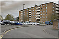
Park Farm flats and car park
These flats have been here for around 60 years give or take a few. The car park edge we can see is for the Park Farm Shopping Centre.
Image: © Malcolm Neal
Taken: 13 Apr 2017
0.14 miles
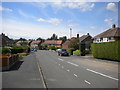
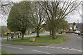
2
Beeley Close, Allestree
Marked out for car parking in connection with the nearby University of Derby main campus; parking appears indicated on both sides of the road, even though that would result in the road being blocked completely.
Image: © Richard Vince
Taken: 11 Aug 2018
0.15 miles
3
Markeaton Golf Course
Has not been a golf course for a long time. Now a housing estate. The path with the no cycling sign used to pass a trig point. Long since demolished.
Image: © Richard Webb
Taken: 22 Feb 2004
0.18 miles
4
East end of Fairway Crescent, Allestree
Image: © Richard Vince
Taken: 11 Aug 2018
0.19 miles
5
The Markeaton Pub
A large pub that is at present closed due to Covid-19 lockdown.
Image: © Malcolm Neal
Taken: 8 Mar 2021
0.19 miles
6
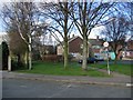
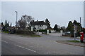
Birchover Way - Ferrers Avenue junction
The narrow Ferrers Avenue meets Birchover way at this small grassy triangle.
Image: © Malcolm Neal
Taken: 13 Apr 2017
0.21 miles
7
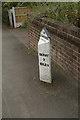
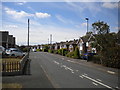
A period milestone
Just past the Woodlands Tennis Club, this tells the distance to the centre of Derby. This is measured from near the cathedral. The marker is now well within the city limits.
Image: © Malcolm Neal
Taken: 27 Apr 2017
0.21 miles
8
Milepost on Kedleston Road, Allestree
Milepost on Kedleston Road, Allestree
http://www.picturesofderby.co.uk/area_allestree.htm
Image: © mike smith
Taken: Unknown
0.22 miles
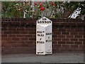
9
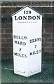
Old Milepost in Kedleston Road, Allestree
Cast iron post by the UC road, in parish of Derby (Derby District), Kedleston Road, Allestree, South of Quarndon, in tarmac path in front of brick wall, on West side of road. Hulland iron casting, erected by the Wirksworth & Derby turnpike trust in the 19th century.
Inscription reads:-
: HULLᴺᴰ. / WARD / 7 / MILES : : 128 / LONDON / MARKEATON : : DERBY / 2 / MILES : Maker:-
: J. HAYWOOD JUNᴿ. / PHOENIX FOUNDRY / DERBY :
Derbyshire HER.
HER No.: 32183 https://www.heritagegateway.org.uk/Gateway/Results_Single.aspx?uid=MDR10317&resourceID=1023
Milestone Society National ID: DE_DEHW02
Image: © J Higgins
Taken: 1 Feb 2002
0.22 miles
10
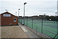
Woodlands Tennis Club
A private members tennis club with seven hard courts.
Image: © Malcolm Neal
Taken: 8 Mar 2021
0.23 miles