IMAGES TAKEN NEAR TO
DE22 2FH
Introduction
This page details the photographs taken nearby to DE22 2FH by members of the Geograph project.
The Geograph project started in 2005 with the aim of publishing, organising and preserving representative images for every square kilometre of Great Britain, Ireland and the Isle of Man.

There are currently over 7.5m images from over14,400 individuals and you can help contribute to the project by visiting https://www.geograph.org.uk
Image Map
Images are licensed for reuse under creativecommons.org/licenses/by-sa/2.0
Notes
- Clicking on the map will re-center to the selected point.
- The higher the marker number, the further away the image location is from the centre of the postcode.
Image Listing (20 Images Found)
Images are licensed for reuse under creativecommons.org/licenses/by-sa/2.0
Image
Details
Distance
1
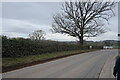
The development continues
The development called Kedleston Grange continues to be built as can be seen beyond the line of hedges to the left of the image.
Image: © Malcolm Neal
Taken: 23 Aug 2021
0.10 miles
2
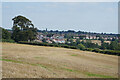
Prospect of Derby
A view of the fields to the west of the city; the cathedral and university.
Image: © Peter Barr
Taken: 28 Jan 2011
0.14 miles
3
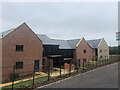
New housing development on the outskirts of Derby
Image: © Eirian Evans
Taken: 30 Jul 2022
0.17 miles
4
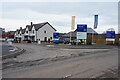
The new development off Kedleston Road
Developed by Millar Homes this is a large development of approximately 400 homes. This is the present entrance to the estate which has a long way to go before it is completed.
Image: © Malcolm Neal
Taken: 8 Mar 2021
0.17 miles
5
Kedleston Road
Walking along Kedleston Road towards Quarndon, ghowever we will turn to the left before we reach the satellite village and return to Derby through open countryside.
Image: © Malcolm Neal
Taken: 8 Mar 2021
0.17 miles
6
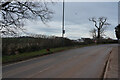
Kedleston Road
Looking across kedleston Road to the new development which is in fields below the level of the road.
Image: © Malcolm Neal
Taken: 8 Mar 2021
0.18 miles
7
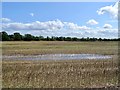
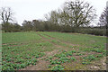
Boggy field
There was a gravel pit marked here on the 1881 Ordnance Survey map. This may explain why the field is so low-lying and boggy.
Image: © Ian Calderwood
Taken: 17 Aug 2019
0.19 miles
8
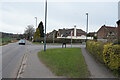
Askerfield Avenue
Askerfield Avenue joins Kedleston Road just ahead. It is the route into a newer part of Allestree in that the houses here have been erected for rather more than 50 years.
Image: © Malcolm Neal
Taken: 8 Mar 2021
0.21 miles
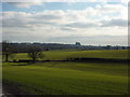
9
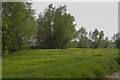
The edge of the field
The trees and hedges form the boundary to this field of cereal crops. The crop is wheat, I think, and even with the lack of rain seems to be growing very well.
Image: © Malcolm Neal
Taken: 11 May 2017
0.22 miles
10
The Markeaton Brook
Invisible below the hedge is the narrow Markeaton Brook. We cross this and then turn left to head back into Derby.
Image: © Malcolm Neal
Taken: 8 Mar 2021
0.22 miles