IMAGES TAKEN NEAR TO
Duffield Road, DERBY, DE22 1ET
Introduction
This page details the photographs taken nearby to Duffield Road, DE22 1ET by members of the Geograph project.
The Geograph project started in 2005 with the aim of publishing, organising and preserving representative images for every square kilometre of Great Britain, Ireland and the Isle of Man.

There are currently over 7.5m images from over14,400 individuals and you can help contribute to the project by visiting https://www.geograph.org.uk
Image Map
Images are licensed for reuse under creativecommons.org/licenses/by-sa/2.0
Notes
- Clicking on the map will re-center to the selected point.
- The higher the marker number, the further away the image location is from the centre of the postcode.
Image Listing (16 Images Found)
Images are licensed for reuse under creativecommons.org/licenses/by-sa/2.0
Image
Details
Distance
6
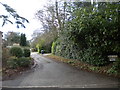
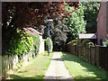
Friars' Close, Darley Abbey
Private road off Church Lane.
Image: © Richard Vince
Taken: 21 Dec 2019
0.12 miles
7
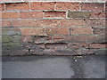
Bench mark on Old Vicarage wall
This bench mark was established in 1851 during the First primary levelling of England & Wales, and was levelled with a height of 265.8810 feet [81.0405 metres] above mean sea level (Liverpool datum). It was included on the Sheffield to Birmingham (Branch Levelling to Darley Church) levelling line. The surveyor's description was "No. 6. Mark on brick wall in front of the Reverend Mr. Griffith's house ; 0.92 ft. above surface" (p364). The 1881-2 map shows this mark on the west face of the wall, east side of road, 5m south of the entrance. It is not shown on subsequent maps. The arrow is lost to a spalled brick, but the datum line is clear.
Image: © Shantavira
Taken: 14 Mar 2015
0.13 miles
8
South Avenue, Darley Abbey (1)
From close to the junction with Church Lane.
Image: © Richard Vince
Taken: 21 Dec 2019
0.13 miles
9
Footpath and cycle path to Darley Abbey Drive
Image: © Ian Calderwood
Taken: 16 Aug 2016
0.15 miles
10
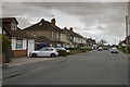
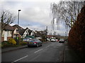
Cavendish Avenue
A housing estate that has been on the edge of Derby for quite a while. It is a very mixed area of bungalows, semi-detached and detached housing.
Image: © Malcolm Neal
Taken: 13 Apr 2017
0.15 miles