IMAGES TAKEN NEAR TO
Merchant Avenue, DERBY, DE21 7NA
Introduction
This page details the photographs taken nearby to Merchant Avenue, DE21 7NA by members of the Geograph project.
The Geograph project started in 2005 with the aim of publishing, organising and preserving representative images for every square kilometre of Great Britain, Ireland and the Isle of Man.

There are currently over 7.5m images from over14,400 individuals and you can help contribute to the project by visiting https://www.geograph.org.uk
Image Map
Images are licensed for reuse under creativecommons.org/licenses/by-sa/2.0
Notes
- Clicking on the map will re-center to the selected point.
- The higher the marker number, the further away the image location is from the centre of the postcode.
Image Listing (36 Images Found)
Images are licensed for reuse under creativecommons.org/licenses/by-sa/2.0
Image
Details
Distance
1
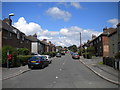
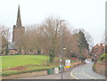
Merchant Avenue, Spondon
This quiet residential street is connected to the outside world via the roundabout at the junction of the A52 with the A6005.
Image: © Richard Vince
Taken: 7 Jul 2012
0.12 miles
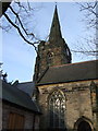
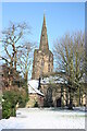
3
St Werburgh's church, Spondon
The church was completely rebuilt after a fire in 1340 and heavily restored in 1826 and the 1890s
Image: © Tim Glover
Taken: 20 Jan 2002
0.16 miles
5
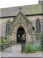
North porch, St Werburgh's Church, Spondon
Probably dating from the major restoration at the end of the 19th century. There is a bench mark http://www.geograph.org.uk/photo/3979222 on the right hand buttress.
Image: © Alan Murray-Rust
Taken: 4 May 2014
0.16 miles
6
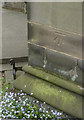
Bench mark, St Werburgh's Church, Spondon
See http://www.geograph.org.uk/photo/3979233 for location.
Image: © Alan Murray-Rust
Taken: 4 May 2014
0.16 miles
8
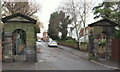
Spondon village, Derbys.
An easterly view along Park Road towards Church Street. These stone gate piers mark the exit from the grounds of "Field House" (a former grand residence or Hall). The residence was built c.1750 for the Osborne family. Having fallen into disrepair c.1918 it was bought by the local Education Authority and is now the site of a school. The gates are all that remain of the property and they now serve to mark the entrance into the West Park School car park. They also serve as one of the access points into the West Park Meadows Local Nature Reserve.
Image: © David Hallam-Jones
Taken: 19 Jan 2014
0.16 miles
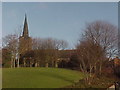
9
Spondon village, Derbys.
This Grade II-listed Anglican church - St Werburgh's - stands at the top of a hill in the centre of the original village. This picture is taken from Lodge Lane (the A6096, Spondon to Ilkeston Road). The main body of the church, i.e. the nave and chancel, along with the 35 metre high tower and spire, date to 1390. The north wall of the nave was rebuilt in 1826 to correct damage caused by subsidence. St Werburgh was born c650, the daughter of King Wulfhere and Queen Ermenhilda of Mercia. Against her father's wishes she became a nun and was she eventually entered Ely Abbey. She subsequently became an Abbess and finally the senior Abbess of all Mercia. She died on 3rd February 700.
Image: © David Hallam-Jones
Taken: 19 Jan 2014
0.16 miles
10
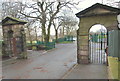
Spondon village, Derbys.
A westward view from the cul-de-sac end of Park Road. These stone gate piers mark the entrance to the former "Field House" (a.k.a. The Hall). This residence was built c.1750 for the Osborne family. Having fallen into disrepair c.1918 it was bought by the local Education Authority and is now the site of a school. The gates are all that remain of the property and they now serve to mark the entrance of West Park School and also, one of the access points into the West Park Meadows Local Nature Reserve. The nature reserve is accessed via a sloping asphalted path beyond the left hand archway.
Image: © David Hallam-Jones
Taken: 19 Jan 2014
0.16 miles