IMAGES TAKEN NEAR TO
Uxbridge Street, BURTON-ON-TRENT, DE14 3JY
Introduction
This page details the photographs taken nearby to Uxbridge Street, DE14 3JY by members of the Geograph project.
The Geograph project started in 2005 with the aim of publishing, organising and preserving representative images for every square kilometre of Great Britain, Ireland and the Isle of Man.

There are currently over 7.5m images from over14,400 individuals and you can help contribute to the project by visiting https://www.geograph.org.uk
Image Map
Images are licensed for reuse under creativecommons.org/licenses/by-sa/2.0
Notes
- Clicking on the map will re-center to the selected point.
- The higher the marker number, the further away the image location is from the centre of the postcode.
Image Listing (26 Images Found)
Images are licensed for reuse under creativecommons.org/licenses/by-sa/2.0
Image
Details
Distance
1
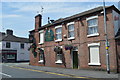
Broadway Street, Burton-on-Trent
Part of the Uxbridge district of the town which saw mushroom growth between 1850-1880 largely to accommodate brewery workers.
Image: © Brian Chadwick
Taken: 25 Sep 2012
0.08 miles
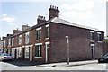
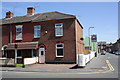
2
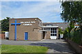
The Kings Way Church - Queen Street
Modern church among Victorian terrace properties.
Image: © John M
Taken: 12 Jul 2014
0.12 miles
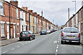
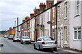
3
King Street - Burton-on-Trent
Photographed from the All saints Road end.
Part of the Uxbridge district of the town which saw mushroom growth between 1850-1880 largely to accommodate brewery workers.
Image: © Brian Chadwick
Taken: 25 Sep 2012
0.14 miles
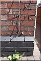
4
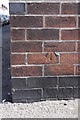
Benchmark on #59 All Saints Road
Ordnance Survey cut mark benchmark described on the Bench Mark Database at http://www.bench-marks.org.uk/bm48775
Image: © Roger Templeman
Taken: 25 May 2013
0.14 miles
5
Junction of South Oak Street and All Saints Road
There is an OS benchmark Image on the corner of the nearest house, just above the pavement below the South Oak St. name sign
Image: © Roger Templeman
Taken: 25 May 2013
0.14 miles
6
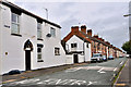
All Saints Road, Burton-on-Trent
Part of the Uxbridge district of the town which saw mushroom growth between 1850-1880 largely to accommodate brewery workers.
Image: © Brian Chadwick
Taken: 25 Sep 2012
0.16 miles
7
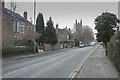
Looking towards Branston
Looking along the Branston Road towards Branston with the church of All Saints in the distance.
Image: © Malcolm Neal
Taken: 28 Feb 2018
0.18 miles
8
Junction of Branston Road and Trent Street
There is an OS benchmark Image on the corner of the corner house on the left side of a cable which runs up the wall
Image: © Roger Templeman
Taken: 25 May 2013
0.19 miles
9
Benchmark on #56 Branston Road
Ordnance Survey cut mark benchmark described on the Bench Mark Database at http://www.bench-marks.org.uk/bm31772
Image: © Roger Templeman
Taken: 25 May 2013
0.19 miles