
IMAGES TAKEN NEAR TO
Palmer Close, BURTON-ON-TRENT, DE14 3DY
Introduction
This page details the photographs taken nearby to Palmer Close, DE14 3DY by members of the Geograph project.
The Geograph project started in 2005 with the aim of publishing, organising and preserving representative images for every square kilometre of Great Britain, Ireland and the Isle of Man.

There are currently over 7.5m images from over14,400 individuals and you can help contribute to the project by visiting https://www.geograph.org.uk
Image Map
Images are licensed for reuse under creativecommons.org/licenses/by-sa/2.0
Notes
- Clicking on the map will re-center to the selected point.
- The higher the marker number, the further away the image location is from the centre of the postcode.
Image Listing (14 Images Found)
Images are licensed for reuse under creativecommons.org/licenses/by-sa/2.0
Image
Details
Distance
1
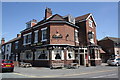
The New Talbot, junction of South Oak Street and Anglesey Road
Anglesey Road is the B5017
Image: © Roger Templeman
Taken: 25 May 2013
0.09 miles
2
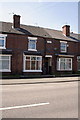
Houses of Whitcliffe Place, Anglesey Road
There is an OS benchmark Image on the bricks to the right of the door entrance
Image: © Roger Templeman
Taken: 25 May 2013
0.16 miles
3
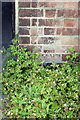
Benchmark on #272 Anglesey Road
Ordnance Survey cut mark benchmark described on the Bench Mark Database at http://www.bench-marks.org.uk/bm48774
Image: © Roger Templeman
Taken: 25 May 2013
0.16 miles
4
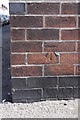
Benchmark on #59 All Saints Road
Ordnance Survey cut mark benchmark described on the Bench Mark Database at http://www.bench-marks.org.uk/bm48775
Image: © Roger Templeman
Taken: 25 May 2013
0.19 miles
5
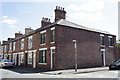
Junction of South Oak Street and All Saints Road
There is an OS benchmark Image on the corner of the nearest house, just above the pavement below the South Oak St. name sign
Image: © Roger Templeman
Taken: 25 May 2013
0.19 miles
6
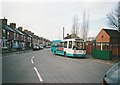
Bus at south end of Anglesey Road, Burton upon Trent
Arriva Midlands 2008, a Dennis Dart/East Lancs EL2000 that began life with Midland Red North, arrives at the nominal terminus of route 13 from Beam Hill via Burton town centre. At this time, local services around Burton and Swadlincote were mainly operated with step entrance Darts, several of which were from this batch that had originally been based in Shrewsbury and Cannock. The road was widened here, where it meets Branston Road, to enable buses to turn; by this time, however, they merely turned left to head back into town along Branston Road (behind the photographer).
Image: © Richard Vince
Taken: 2 Mar 2007
0.22 miles
7
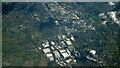
Burton Upon Trent from the air
Looking east over the town from a Luton bound flight from Glasgow.
Image: © Thomas Nugent
Taken: 17 Apr 2024
0.23 miles
8
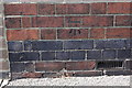
Benchmark on #110 Beech Street
Ordnance Survey cut mark benchmark described on the Bench Mark Database at http://www.bench-marks.org.uk/bm48773
Image: © Roger Templeman
Taken: 25 May 2013
0.23 miles
9
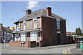
Junctions of All Saints Road with Beech Street and Anglesey Road
There is an OS benchmark Image on the near corner of the house at the junction with the front garden wall
Image: © Roger Templeman
Taken: 25 May 2013
0.23 miles
10
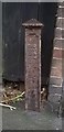
Old Boundary Marker by the B5018, Branston Road, Burton on Trent
Municipal Boundary Marker on the northern edge of Leicester Line railway property next to the front door of No. 139 on the west side of Branston Road. The vertical legend reads BURTON UPON TRENT / BOROUGH BOUNDARY with the foundry name PP HALBAND / BRITANNIA / FOUNDRY horizontally at the base. Erected 1878 to mark the boundary of Burton on Trent borough. At that time on the boundary of Branston and Burton Extra parishes, now Branston and Anglesey parishes.
Milestone Society National ID: ST_BURT01pb
Image: © L Watson
Taken: Unknown
0.23 miles