Old Boundary Marker by the B5018, Branston Road, Burton on Trent
Introduction
The photograph on this page of Old Boundary Marker by the B5018, Branston Road, Burton on Trent by L Watson as part of the Geograph project.
The Geograph project started in 2005 with the aim of publishing, organising and preserving representative images for every square kilometre of Great Britain, Ireland and the Isle of Man.

There are currently over 7.5m images from over 14,400 individuals and you can help contribute to the project by visiting https://www.geograph.org.uk
Old Boundary Marker by the B5018, Branston Road, Burton on Trent
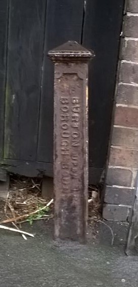
Image: © L Watson Taken: Unknown
Municipal Boundary Marker on the northern edge of Leicester Line railway property next to the front door of No. 139 on the west side of Branston Road. The vertical legend reads BURTON UPON TRENT / BOROUGH BOUNDARY with the foundry name PP HALBAND / BRITANNIA / FOUNDRY horizontally at the base. Erected 1878 to mark the boundary of Burton on Trent borough. At that time on the boundary of Branston and Burton Extra parishes, now Branston and Anglesey parishes. Milestone Society National ID: ST_BURT01pb
Images are licensed for reuse under creativecommons.org/licenses/by-sa/2.0
Image Location
Latitude
52.790763
Longitude
-1.644511