
IMAGES TAKEN NEAR TO
Wood Street, BURTON-ON-TRENT, DE14 3AB
Introduction
This page details the photographs taken nearby to Wood Street, DE14 3AB by members of the Geograph project.
The Geograph project started in 2005 with the aim of publishing, organising and preserving representative images for every square kilometre of Great Britain, Ireland and the Isle of Man.

There are currently over 7.5m images from over14,400 individuals and you can help contribute to the project by visiting https://www.geograph.org.uk
Image Map
Images are licensed for reuse under creativecommons.org/licenses/by-sa/2.0
Notes
- Clicking on the map will re-center to the selected point.
- The higher the marker number, the further away the image location is from the centre of the postcode.
Image Listing (23 Images Found)
Images are licensed for reuse under creativecommons.org/licenses/by-sa/2.0
Image
Details
Distance
1
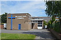
The Kings Way Church - Queen Street
Modern church among Victorian terrace properties.
Image: © John M
Taken: 12 Jul 2014
0.09 miles
4
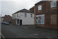
James Street
James street at its junction with Uxbridge Street has a couple of houses that are partially bricked up. This small area seems to be rather run down.
Image: © Malcolm Neal
Taken: 28 Feb 2018
0.13 miles
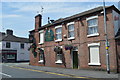
6
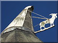
Goat and cowl on a former brewery
This on top of an octagonal kiln that is part of a long disused brewery and maltings in Burton-on-Trent. Although much has been lost, there are still significant remains to be seen.
Image: © Chris Allen
Taken: 10 Feb 2016
0.15 miles
7
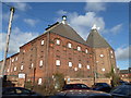
Former brewery and maltings - Burton-on-Trent
The cowl on the maltings bears a goat to act as a wind-vane. These buildings are derelict and look ripe for redevelopment. Nearby, the former Trent Brewery has been converted to apartments.
Image: © Chris Allen
Taken: 10 Feb 2016
0.17 miles
8
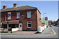
Junction of Branston Road and Trent Street
There is an OS benchmark Image on the corner of the corner house on the left side of a cable which runs up the wall
Image: © Roger Templeman
Taken: 25 May 2013
0.18 miles
9
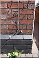
Benchmark on #56 Branston Road
Ordnance Survey cut mark benchmark described on the Bench Mark Database at http://www.bench-marks.org.uk/bm31772
Image: © Roger Templeman
Taken: 25 May 2013
0.19 miles
10

Shops at junction of Park Street and Uxbridge Street
There is an OS benchmark Image on the side of the autoparts shop to the right of the Park Street name sign
Image: © Roger Templeman
Taken: 25 May 2013
0.20 miles