IMAGES TAKEN NEAR TO
Derby Road, BURTON-ON-TRENT, DE14 1RP
Introduction
This page details the photographs taken nearby to Derby Road, DE14 1RP by members of the Geograph project.
The Geograph project started in 2005 with the aim of publishing, organising and preserving representative images for every square kilometre of Great Britain, Ireland and the Isle of Man.

There are currently over 7.5m images from over14,400 individuals and you can help contribute to the project by visiting https://www.geograph.org.uk
Image Map
Images are licensed for reuse under creativecommons.org/licenses/by-sa/2.0
Notes
- Clicking on the map will re-center to the selected point.
- The higher the marker number, the further away the image location is from the centre of the postcode.
Image Listing (26 Images Found)
Images are licensed for reuse under creativecommons.org/licenses/by-sa/2.0
Image
Details
Distance
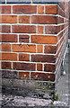
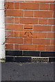
1
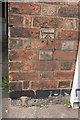
Benchmark on #63 Derby Road
Ordnance Survey cut mark benchmark described on the Bench Mark Database at http://www.bench-marks.org.uk/bm48650
Image: © Roger Templeman
Taken: 17 May 2013
0.07 miles
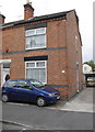
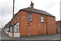
2
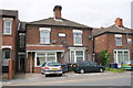
#63 Derby Road
There is an OS benchmark Image on the front of the house between the white downpipe on the corner
Image: © Roger Templeman
Taken: 17 May 2013
0.08 miles
3
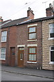
#189 Stafford Street
There is an OS benchmark Image on the front of the house between the door and the window sill
Image: © Roger Templeman
Taken: 17 May 2013
0.12 miles
4
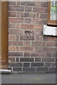
Benchmark on #189 Stafford Street
Ordnance Survey cut mark benchmark described on the Bench Mark Database at http://www.bench-marks.org.uk/bm48649
Image: © Roger Templeman
Taken: 17 May 2013
0.12 miles
5
#62 Stafford Street
There is an OS benchmark Image on the front of the house right of the car
Image: © Roger Templeman
Taken: 17 May 2013
0.12 miles
6
Benchmark on #62 Stafford Street
Ordnance Survey cut mark benchmark described on the Bench Mark Database at http://www.bench-marks.org.uk/bm48648
Image: © Roger Templeman
Taken: 17 May 2013
0.12 miles
7
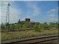
Industrial premises off Derby Road, Burton-on-Trent
Viewed from the Derby train heading towards Burton Station. See http://www.geograph.org.uk/photo/2982920
Image: © Neil Theasby
Taken: 22 Sep 2014
0.13 miles
8
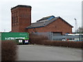
Former hydraulic power station
This provided power to the nearby railway sidings and No. 4 bonded store and grain warehouse in Burton-on-Trent. As new it would undoubtedly have had a chimney. The tower would have held accumulators (and may still do so).
Image: © Chris Allen
Taken: 19 Mar 2016
0.13 miles
9
Houses at Sydney Street / Stafford Street junction
There is an OS benchmark Image on the corner of the near house near the junction with the white wall
Image: © Roger Templeman
Taken: 17 May 2013
0.13 miles
10
Benchmark on #17 Sydney Street
Ordnance Survey cut mark benchmark described on the Bench Mark Database at http://www.bench-marks.org.uk/bm48595
Image: © Roger Templeman
Taken: 17 May 2013
0.13 miles