IMAGES TAKEN NEAR TO
Meadow View Close, BURTON-ON-TRENT, DE13 8FP
Introduction
This page details the photographs taken nearby to Meadow View Close, DE13 8FP by members of the Geograph project.
The Geograph project started in 2005 with the aim of publishing, organising and preserving representative images for every square kilometre of Great Britain, Ireland and the Isle of Man.

There are currently over 7.5m images from over14,400 individuals and you can help contribute to the project by visiting https://www.geograph.org.uk
Image Map
Images are licensed for reuse under creativecommons.org/licenses/by-sa/2.0
Notes
- Clicking on the map will re-center to the selected point.
- The higher the marker number, the further away the image location is from the centre of the postcode.
Image Listing (55 Images Found)
Images are licensed for reuse under creativecommons.org/licenses/by-sa/2.0
Image
Details
Distance
1
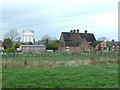
Water tower again - Hanbury, Staffordshire
A most prominent feature of this village of Hanbury here in Staffordshire is this water tower. Built in 1936, this is sited between Martin's Lane and Oakfields, seen from westwards from Martin's Lane. This village is not to be confused with the village of Hanbury in Worcestershire. Time photo taken 12.22 pm BST (British Summer Time).
Image: © Martin Richard Phelan
Taken: 14 Apr 2012
0.02 miles
2
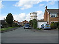
Water tower - Hanbury, Staffordshire
A most prominent feature of this village of Hanbury here in Staffordshire is this water tower. Built in 1936, this is sited between Martin's Lane and Oakfields, seen from eastwards from Hanbury Hill. This village is not to be confused with the village of Hanbury in Worcestershire. Time taken 11.17 am BST (British Summer Time).
Image: © Martin Richard Phelan
Taken: 14 Apr 2012
0.02 miles
3
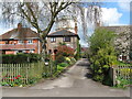
Oakfields, Hanbury, showing the Water Tower
Image: © Mick Malpass
Taken: 6 Nov 2011
0.04 miles
4
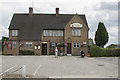
The Cock Inn
Hanbury village pub is called the Cock Inn. As usual it seems to do meals as well as drinks.
Image: © Malcolm Neal
Taken: 9 Aug 2018
0.05 miles
5
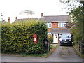
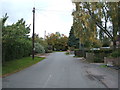
House on Martin's Lane, Hanbury
The former Post Office.
Showing position of Postbox No. DE13 1152.
See Image] for postbox.
Image: © JThomas
Taken: 7 Oct 2017
0.06 miles
6
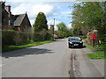
Church Lane 1 - Hanbury, Staffordshire
North west of Burton upon Trent, the parish church has the oldest alabaster effigy in England, of Sir John Hanbury who died in 1303.
Also remembered are Royalist Sir John Egerton, two Puritan ladies (of which more in the church) and the 70 people who lost their lives in the RAF (Royal Air Force) Fauld bomb dump explosion on 27th November 1944. The village has its prominent water tower and the Cock Inn, where there is displayed material relating to the Fauld explosion. Only the Fauld Crater remains, away to the east of the village, where tree cover is blurring its once harsh outline. Time taken 12.21 pm BST (British Summer Time).
Image: © Martin Richard Phelan
Taken: 14 Apr 2012
0.06 miles
7
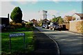
The Cock Inn and a water tower, Hanbury
Seen from the footpath to the crater.
Image: © Humphrey Bolton
Taken: 14 Nov 2009
0.07 miles
8
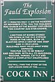
Sign at the Cock Inn, Hanbury
Giving information about the Fauld explosion.
Image: © Humphrey Bolton
Taken: 12 Nov 2009
0.07 miles
9
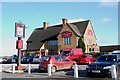
The Cock Inn Hanbury on a Busy Sunday Morning
This public house had to be demolished after the fauld explosion nearby.http://www.cockinn-hanbury.co.uk/
Image: © Mick Malpass
Taken: 6 Nov 2011
0.07 miles