IMAGES TAKEN NEAR TO
Wentworth Drive, BURTON-ON-TRENT, DE13 0YJ
Introduction
This page details the photographs taken nearby to Wentworth Drive, DE13 0YJ by members of the Geograph project.
The Geograph project started in 2005 with the aim of publishing, organising and preserving representative images for every square kilometre of Great Britain, Ireland and the Isle of Man.

There are currently over 7.5m images from over14,400 individuals and you can help contribute to the project by visiting https://www.geograph.org.uk
Image Map
Images are licensed for reuse under creativecommons.org/licenses/by-sa/2.0
Notes
- Clicking on the map will re-center to the selected point.
- The higher the marker number, the further away the image location is from the centre of the postcode.
Image Listing (4 Images Found)
Images are licensed for reuse under creativecommons.org/licenses/by-sa/2.0
Image
Details
Distance
1
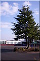
Stretton Community School
A special school formed by amalgamation of two schools.
Image: © S Parish
Taken: 11 Apr 2007
0.17 miles
3
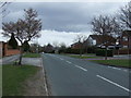
Bitham Lane heading east
Towards Craythorne.
Image: © JThomas
Taken: 19 Apr 2013
0.17 miles
4
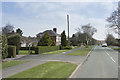
Bitham Lane
Looking along Bitham Lane on a sunny afternoon on the north edge of Stretton a suburb of Burton on Trent.
Image: © Malcolm Neal
Taken: 14 Apr 2018
0.23 miles