
IMAGES TAKEN NEAR TO
Calais Road, BURTON-ON-TRENT, DE13 0UQ
Introduction
This page details the photographs taken nearby to Calais Road, DE13 0UQ by members of the Geograph project.
The Geograph project started in 2005 with the aim of publishing, organising and preserving representative images for every square kilometre of Great Britain, Ireland and the Isle of Man.

There are currently over 7.5m images from over14,400 individuals and you can help contribute to the project by visiting https://www.geograph.org.uk
Image Map
Images are licensed for reuse under creativecommons.org/licenses/by-sa/2.0
Notes
- Clicking on the map will re-center to the selected point.
- The higher the marker number, the further away the image location is from the centre of the postcode.
Image Listing (5 Images Found)
Images are licensed for reuse under creativecommons.org/licenses/by-sa/2.0
Image
Details
Distance
1
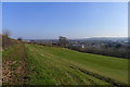
View over Burton on Trent from the Outwood Hills
Image: © Tim Heaton
Taken: 2 Mar 2013
0.11 miles
2
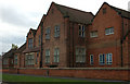
Board of Guardian's Office
This is part of the Queen's Hospital, Burton on Trent and faces on to Belvoir Road. It was originally built in the 1880s as part of the Burton Union Workhouse and served the function of Board of Guardian's Office and Board Room.
Image: © Phil Myott
Taken: 11 Nov 2007
0.18 miles
3
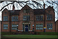
Master's House
This was the Master's House for Burton Union Workhouse and was built in 1882. Behind it was the dining rooms and kitchens. It now stands in the grounds of the Queen's Hospital and forms part of the Burton Hospital NHS Trust.
Image: © Phil Myott
Taken: 11 Nov 2007
0.22 miles
4
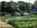
Bradmore Road Allotments
Controlled by Horninglow & Eaton Parish Council.
Image: © Ian Calderwood
Taken: 28 Jun 2019
0.22 miles
5
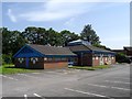
Burton Amateur Boxing Club
Originally based in a pigeon loft at The Gardens pub in Ferry Street, Stapenhill, the club moved to these purpose-built premises in 2003.
Image: © Ian Calderwood
Taken: 28 Jun 2019
0.23 miles