
IMAGES TAKEN NEAR TO
St. Andrews Drive, BURTON-ON-TRENT, DE13 0LG
Introduction
This page details the photographs taken nearby to St. Andrews Drive, DE13 0LG by members of the Geograph project.
The Geograph project started in 2005 with the aim of publishing, organising and preserving representative images for every square kilometre of Great Britain, Ireland and the Isle of Man.

There are currently over 7.5m images from over14,400 individuals and you can help contribute to the project by visiting https://www.geograph.org.uk
Image Map
Images are licensed for reuse under creativecommons.org/licenses/by-sa/2.0
Notes
- Clicking on the map will re-center to the selected point.
- The higher the marker number, the further away the image location is from the centre of the postcode.
Image Listing (24 Images Found)
Images are licensed for reuse under creativecommons.org/licenses/by-sa/2.0
Image
Details
Distance
1

Footpath to Farm Road
Farm Road was previously called Dog Lane.
Image: © Ian Calderwood
Taken: 23 Aug 2019
0.13 miles
2
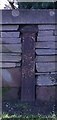
Old Boundary Marker by Rolleston Road, Burton on Trent
Municipal Boundary Marker set in a stone wall on the east side of Rolleston Road. The vertical legend reads BURTON UPON TRENT / BOROUGH BOUNDARY with the foundry name PP HALBAND / BRITANNIA / FOUNDRY horizontally at the base. Erected 1878 to mark the boundary of Burton on Trent borough. At that time in Horninglow parish, now on the boundary of Stretton and Horninglow and Eton parishes. Previously on the west side of the road. See also http://www.geograph.org.uk/photo/3987093.
Milestone Society National ID: ST_BURT11pb
Image: © L Watson
Taken: Unknown
0.13 miles
3

Rolleston Road in Horninglow
Looking southward.
Image: © Peter Wood
Taken: 19 Jul 2016
0.17 miles
4
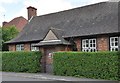
Former Parish Room - Horninglow
The building is situated on the Rolleston Road. The Parish Room of St John the Divine Horninglow is situated in the grounds of the vicarage for St. John's Church.It is a single room with toilet facililties. In the 1940's the room housed the Reception Class for the then Horninglow Junior Mixed and Infants' School whose main building was on Horninglow Road.
Image: © Brian Chadwick
Taken: 26 May 2009
0.17 miles
5
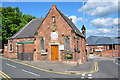
School opened in 1846 - now meeting room
Situated on the corner of Farm Road and Horninglow Road North, Horninglow. It was erected in 1846 by voluntary contributions with the aid of a grant from the Committee of the Privy Council on Education and from the National Society for the Education of the poor in the principles of the Established Church on a site presented by the Most Honourable Henry William Marquis of Anglesey.
Image: © Brian Chadwick
Taken: 28 May 2009
0.19 miles
6
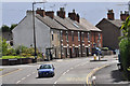
The junction of Tutbury Road with Horninglow Road North.
Image: © Brian Chadwick
Taken: 28 Aug 2009
0.20 miles
7
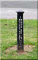
Burton Upon Trent Borough Boundary
One of a series of similar cast iron boundary posts on the line of the former borough boundary from the mid-Victorian period. This is in Horninglow Community Park http://www.geograph.org.uk/photo/4181147
Image: © Alan Murray-Rust
Taken: 20 Sep 2014
0.21 miles
8
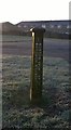
Old Boundary Marker in Horninglow Park, Burton on Trent
Municipal Boundary Marker in the west corner of Horninglow Park just off St Lukes Road. The vertical legend reads BURTON UPON TRENT / BOROUGH BOUNDARY with the foundry name PP HALBAND / BRITANNIA / FOUNDRY horizontally at the base. Erected 1878 to mark the boundary of Burton on Trent borough. At that time on the boundary of Stretton and Horninglow parishes, now entirely in Horninglow and Eton parish. See also https://www.geograph.org.uk/photo/4181144.
Milestone Society National ID: ST_BURT12pb
Image: © Milestone Society
Taken: Unknown
0.22 miles
9
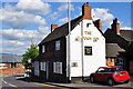
The Plough Inn - Horninglow Road North - Burton-on-Trent
Image: © Brian Chadwick
Taken: 28 May 2009
0.22 miles
10
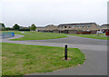
In Horninglow Community Park
The cast iron post http://www.geograph.org.uk/photo/4181144 marks the line of the former Burton borough boundary, which the park now straddles.
Image: © Alan Murray-Rust
Taken: 20 Sep 2014
0.22 miles