IMAGES TAKEN NEAR TO
Bloomfield Close, DERBY, DE1 2FY
Introduction
This page details the photographs taken nearby to Bloomfield Close, DE1 2FY by members of the Geograph project.
The Geograph project started in 2005 with the aim of publishing, organising and preserving representative images for every square kilometre of Great Britain, Ireland and the Isle of Man.

There are currently over 7.5m images from over14,400 individuals and you can help contribute to the project by visiting https://www.geograph.org.uk
Image Map
Images are licensed for reuse under creativecommons.org/licenses/by-sa/2.0
Notes
- Clicking on the map will re-center to the selected point.
- The higher the marker number, the further away the image location is from the centre of the postcode.
Image Listing (255 Images Found)
Images are licensed for reuse under creativecommons.org/licenses/by-sa/2.0
Image
Details
Distance
1
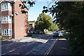
By the Dovedale Day Hospital
The day hospital is part of the NHS and presumably deals with fairly minor issues.
Image: © Malcolm Neal
Taken: 14 Sep 2019
0.02 miles
2
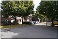
The end of Keble Close
This is the vehicle turning space at the end of Keble Close as it is blocked off from Oxford Street by a series of bollards.
Image: © Malcolm Neal
Taken: 25 Sep 2019
0.05 miles
3
Sidney Street
More modern houses that have replaced old Victorian terraced houses in this area of Derby.
Image: © Malcolm Neal
Taken: 19 Sep 2019
0.07 miles
4
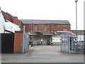
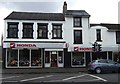
Motorcycle instruction off London Road, Derby
The business is based in former industrial premises off High Street (which despite the name, is now merely a stub of a side street).
Image: © Stephen Craven
Taken: 18 May 2019
0.07 miles
5
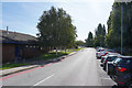
Bloomfield Close
Bloomfield Close is on the other side of Osmaston Road from the Arboretum Park. it is a cul-de-sac of modern houses and flats.
Image: © Malcolm Neal
Taken: 19 Sep 2019
0.07 miles
6
Dovedale Day Hospital, London Road, Derby
Image: © Stephen Craven
Taken: 18 May 2019
0.07 miles
8
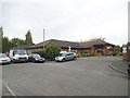
The main entrance to the Community Hospital
The community hospital has no A&E but is still a very busy hospital catering for a range of less serious problems and mainly for older people.
Image: © Malcolm Neal
Taken: 14 Sep 2019
0.08 miles
9

Cycle direction sign, London Road, Derby
Image: © Stephen Craven
Taken: 18 May 2019
0.09 miles
10
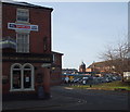
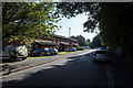
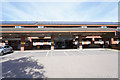
Derby - London Road
The Florence Nightingale pub occupying a corner position at the junction with Oxford Road. Buildings on the former Derbyshire Royal Infirmary site are obvious in the background. The well-used car parks are still being used by NHS staff (and by visitors too perhaps?) although NHS services are now being provided by The London Road Community Hospital located on land to the left of the former hospital.
Image: © David Hallam-Jones
Taken: 29 Nov 2012
0.09 miles