IMAGES TAKEN NEAR TO
Station Drive, SWADLINCOTE, DE12 6EF
Introduction
This page details the photographs taken nearby to Station Drive, DE12 6EF by members of the Geograph project.
The Geograph project started in 2005 with the aim of publishing, organising and preserving representative images for every square kilometre of Great Britain, Ireland and the Isle of Man.

There are currently over 7.5m images from over14,400 individuals and you can help contribute to the project by visiting https://www.geograph.org.uk
Image Map
Images are licensed for reuse under creativecommons.org/licenses/by-sa/2.0
Notes
- Clicking on the map will re-center to the selected point.
- The higher the marker number, the further away the image location is from the centre of the postcode.
Image Listing (22 Images Found)
Images are licensed for reuse under creativecommons.org/licenses/by-sa/2.0
Image
Details
Distance
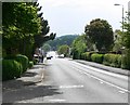
1
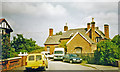
Moira station (site/remains), 2002
View northward on Station Drive. The railway tracks are just over the fence ahead: ex-Midland Leicester - Ashby-de-la-Zouch - Burton-on-Trent line, which closed to passengers 7/9/64, but still carries freight and may soon carry passengers again. Moira station used also to serve trains on the ex-Midland Swadlincote Loop from Gresley: passenger until 19/2/27, goods until 6/10/47, excursions until 9/62; also the Midland & LNWR Joint Ashby - Nuneaton line, which lost its passenger service 13/4/31 but remained for goods until 6/7/64.
Image: © Ben Brooksbank
Taken: 28 Aug 2002
0.02 miles
2
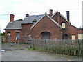
De-railed
Moira railway station has seen better days.
Image: © cris sloan
Taken: 27 Jun 2007
0.03 miles
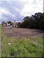
3
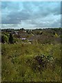
Old Railway Land
A view from the old railway, over the residential housing.
Image: © John Carver
Taken: 24 Aug 2008
0.07 miles
4
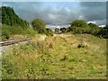
Old Railway Station & Land
The old railway station is in the background, currently having building work carried out (August 2008). The railway tracks are to the left. The land drops away a little to the right of the camera.
Image: © John Carver
Taken: 24 Aug 2008
0.09 miles
6
Disused Railway Sidings Land
The old railway station is in the background, currently having building work carried out (August 2008). The railway tracks are to the left, just out of camera shot.
Image: © John Carver
Taken: 24 Aug 2008
0.09 miles
7
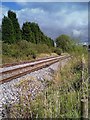
Old Railway Tracks Moira
The old disused railway station is to the right hand side of the photograph.
Image: © John Carver
Taken: 24 Aug 2008
0.10 miles
8
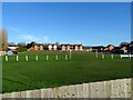
Moira United Football Club
Moira United play in the Burton & District Sunday Football League.
Image: © Ian Calderwood
Taken: 12 Jan 2022
0.10 miles
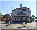
10

Sign for the Rawdon Arms, Moira
See Image] for context.
Image: © JThomas
Taken: 27 Jun 2019
0.15 miles