IMAGES TAKEN NEAR TO
De Ruthyn Close, SWADLINCOTE, DE12 6ED
Introduction
This page details the photographs taken nearby to De Ruthyn Close, DE12 6ED by members of the Geograph project.
The Geograph project started in 2005 with the aim of publishing, organising and preserving representative images for every square kilometre of Great Britain, Ireland and the Isle of Man.

There are currently over 7.5m images from over14,400 individuals and you can help contribute to the project by visiting https://www.geograph.org.uk
Image Map
Images are licensed for reuse under creativecommons.org/licenses/by-sa/2.0
Notes
- Clicking on the map will re-center to the selected point.
- The higher the marker number, the further away the image location is from the centre of the postcode.
Image Listing (7 Images Found)
Images are licensed for reuse under creativecommons.org/licenses/by-sa/2.0
Image
Details
Distance
1
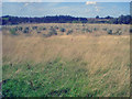
New planting at Hicks Lodge - 2
Looking north-west to the railway embankment on the left. The young saplings cover the whole area up to the railway except for a rough grass strip of clearing near the pathway. The open cast coal mine here is already a memory.
Image: © Trevor Rickard
Taken: 22 Aug 2009
0.13 miles
2
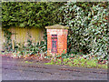
A Victorian postbox (disused), Moira
A compact iron post box, usually mounted on a telegraph pole or on a metal post, here embedded in a purpose-built brick column. Its era is indicated with the marking "V R" (Queen Victoria). The slot blocked with a steel plate, it has been clearly decommissioned in favour of a more recent post box (of the box-on-a-post variety), on the opposite side of the road.
Image: © Oliver Mills
Taken: 31 Dec 2021
0.17 miles
5
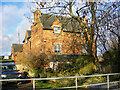
Sweethill Lodge Farm, Moira
A very distinctive feature of this area, with few properties being of this age; it is not often that such stocky, robust and old-fashioned farmhouses are encountered today. The farm was the object of a substantial planning application, whereupon the farmland would be developed into housing and the farmhouse restored into a high-end property. This has not seen progress in the last seven years, so a farm it remains... probably for the better.
Image: © Oliver Mills
Taken: 31 Dec 2021
0.22 miles
6
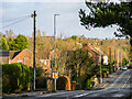
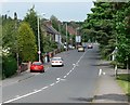
Ashby Road, Moira
Taken from the slightly elevated position on the railway bridge, looking in the Ashby-de-la-Zouch direction. The telegraph pole in the foreground is of the antiquated "pepperpot" insulator variety, and dates from 1952.
Image: © Oliver Mills
Taken: 31 Dec 2021
0.24 miles
7

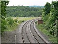
Path in Beehive Wood
Beehive Wood was planted on former farm land in 1997 to compliment the neighbouring Daybell Estate.
Image: © Ian Calderwood
Taken: 17 Jan 2022
0.24 miles