IMAGES TAKEN NEAR TO
Dalhousie Street, BRECHIN, DD9 7BB
Introduction
This page details the photographs taken nearby to Dalhousie Street, DD9 7BB by members of the Geograph project.
The Geograph project started in 2005 with the aim of publishing, organising and preserving representative images for every square kilometre of Great Britain, Ireland and the Isle of Man.

There are currently over 7.5m images from over14,400 individuals and you can help contribute to the project by visiting https://www.geograph.org.uk
Image Map (Loading...)


Getting Data...Please wait
Leaflet Map data © OpenStreetMap
Images are licensed for reuse under creativecommons.org/licenses/by-sa/2.0
Notes
- Clicking on the map will re-center to the selected point.
- The higher the marker number, the further away the image location is from the centre of the postcode.
Image Listing (54 Images Found)
Images are licensed for reuse under creativecommons.org/licenses/by-sa/2.0
Image
Details
Distance
1
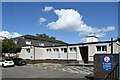
Brechin Health Centre, Infirmary Road, Brechin
Image: © Bill Harrison
Taken: 11 Aug 2023
0.04 miles
2
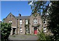
St Drostan's House, Infirmary Street, Brechin
Part of the former Brechin Infirmary and likely to be demolished. Note the jungle-like plant growing inside the window to the left of the red door.
Image: © Bill Harrison
Taken: 11 Aug 2023
0.06 miles
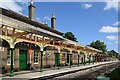
3
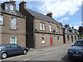
Park Bar, Brechin
Adjacent to the railway station.
Image: © Stanley Howe
Taken: 31 Jul 2007
0.07 miles
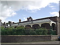
4
Platform canopy reconstruction, Brechin Station
The station closed to passengers in 1952 but is now the base of the preserved Caledonian Railway (Brechin).
Image: © Bill Harrison
Taken: 11 Aug 2023
0.09 miles
5
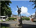
Reach for the sky
Statue of Robert Watson-Watt, the pioneer of radar (https://en.wikipedia.org/wiki/Robert_Watson-Watt ), who was born in Brechin.
Image: © Bill Harrison
Taken: 11 Aug 2023
0.09 miles
6
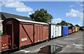
Preserved rolling tock, Brechin Station
Brechin never quite fitted into the railway building plans of the 19th Century and local trains from Forfar to Montrose had to reverse at Brechin Station, which closed to passengers as early as 1952: https://en.wikipedia.org/wiki/Forfar_and_Brechin_Railway . Now the base of the preserved Caledonian Railway (Brechin): https://en.wikipedia.org/wiki/Caledonian_Railway_(Brechin) .
Image: © Bill Harrison
Taken: 11 Aug 2023
0.09 miles
7
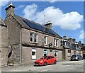
Park Bar, Park Road, Brechin
Like several bars I observed on my stroll around Brechin, it seems to be closed.
Image: © Bill Harrison
Taken: 11 Aug 2023
0.09 miles
8

Brechin Public Library...
...as seen from St Ninian's Square.
Image: © Bill Harrison
Taken: 11 Aug 2023
0.09 miles
9
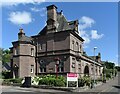
Brechin Public Library
B-listed (LB22570 https://portal.historicenvironment.scot/designation/LB22570 ) and described as "Victorian Renaissance with French and American characteristics".
Image: © Bill Harrison
Taken: 11 Aug 2023
0.09 miles