IMAGES TAKEN NEAR TO
FORFAR, DD8 2TG
Introduction
This page details the photographs taken nearby to DD8 2TG by members of the Geograph project.
The Geograph project started in 2005 with the aim of publishing, organising and preserving representative images for every square kilometre of Great Britain, Ireland and the Isle of Man.

There are currently over 7.5m images from over14,400 individuals and you can help contribute to the project by visiting https://www.geograph.org.uk
Image Map
Images are licensed for reuse under creativecommons.org/licenses/by-sa/2.0
Notes
- Clicking on the map will re-center to the selected point.
- The higher the marker number, the further away the image location is from the centre of the postcode.
Image Listing (10 Images Found)
Images are licensed for reuse under creativecommons.org/licenses/by-sa/2.0
Image
Details
Distance
2
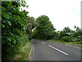
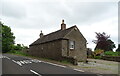
Bend in the B9113, Quarrybank
Towards Montrose.
Image: © JThomas
Taken: 13 Jun 2021
0.07 miles
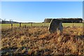
3
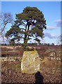
Westerton Standing Stone and Scots Pine
Image: © Dominic Dawn Harry and Jacob Paterson
Taken: 20 Feb 2006
0.08 miles
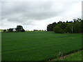
5
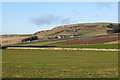
Fields, Westerton
View towards Turin Hill.
Image: © Richard Webb
Taken: 11 Jan 2014
0.18 miles
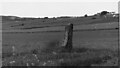
6
Standing stone, Westerton
The stone has cups cut into it and a now faint human figure carving.
Image: © Richard Webb
Taken: 11 Jan 2014
0.18 miles
7
Westerton standing stone
Standing stone with cup marks and an incised figure. https://canmore.org.uk/site/34906/westerton
Image: © Sandy Gerrard
Taken: Unknown
0.19 miles
8
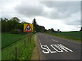
B9113 approaching bends, Quarrybank
Towards Montrose.
Image: © JThomas
Taken: 13 Jun 2021
0.21 miles
9
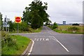
Pitkennedy / Letham Road at its junction with Montrose / Forfar Road
Image: © Alan Morrison
Taken: 23 Sep 2007
0.21 miles