IMAGES TAKEN NEAR TO
FORFAR, DD8 2LJ
Introduction
This page details the photographs taken nearby to DD8 2LJ by members of the Geograph project.
The Geograph project started in 2005 with the aim of publishing, organising and preserving representative images for every square kilometre of Great Britain, Ireland and the Isle of Man.

There are currently over 7.5m images from over14,400 individuals and you can help contribute to the project by visiting https://www.geograph.org.uk
Image Map
Images are licensed for reuse under creativecommons.org/licenses/by-sa/2.0
Notes
- Clicking on the map will re-center to the selected point.
- The higher the marker number, the further away the image location is from the centre of the postcode.
Image Listing (13 Images Found)
Images are licensed for reuse under creativecommons.org/licenses/by-sa/2.0
Image
Details
Distance
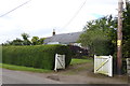
2
Derelict Cottage, Lownie Muir, Forfar
This cottage is probably beyond rescue. Unfortunate as the location is nice!!
Image: © Christopher Gillan
Taken: 4 Feb 2006
0.06 miles
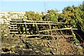
3
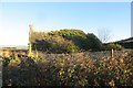
Ruin, Lownie Moor
A bit further gone than when this was taken: Image
Image: © Richard Webb
Taken: 11 Jan 2014
0.07 miles
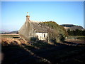
4
Ruin, Lownie Moor
Roof detail showing surviving stones and timbers.
Image: © Richard Webb
Taken: 11 Jan 2014
0.07 miles
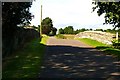
5
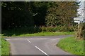
Muir of Lownie road at its junction with the Lour / Kingsmuir Road
Image: © Alan Morrison
Taken: 27 Aug 2007
0.16 miles
6
Cherryfield
Cherryfield is a little hamlet on the edge of Kingsmuir and in the middle of farming country. The Product Packaging unit will be used for packing and distribution of local product.
Image: © Mary Rodgers
Taken: 29 Aug 2020
0.19 miles
7

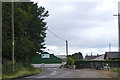
Station House, Lownie Moor
Former station on the Dundee to Forfar line.
Image: © JThomas
Taken: 20 Jul 2021
0.20 miles
8
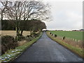
Road to Kingsmuir near Lownie Moor
Looking northwards up the hill on the Kingsmuir to Lour road near Lownie Moor on a wintry afternoon.
Image: © Scott Cormie
Taken: 19 Jan 2018
0.21 miles
9
Station House
This is part of the Dundee and Forfar branch railway; Kingsmuir Station stood where there is now a grassy area north of the overbridge. The sign at the end of the road on the trackbed which leads to the bungalow is signposted to Station House.
Image: © Anne Burgess
Taken: 19 Feb 2015
0.21 miles
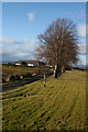
10
Railway Bridge at Muir of Lownie
The railway line, (dismantled for many years) passed under this bridge on its way from Forfar to Kirkbuddo and beyond.
Image: © Alan Morrison
Taken: 27 Aug 2007
0.22 miles