IMAGES TAKEN NEAR TO
New Road, FORFAR, DD8 2AE
Introduction
This page details the photographs taken nearby to New Road, DD8 2AE by members of the Geograph project.
The Geograph project started in 2005 with the aim of publishing, organising and preserving representative images for every square kilometre of Great Britain, Ireland and the Isle of Man.

There are currently over 7.5m images from over14,400 individuals and you can help contribute to the project by visiting https://www.geograph.org.uk
Image Map
Images are licensed for reuse under creativecommons.org/licenses/by-sa/2.0
Notes
- Clicking on the map will re-center to the selected point.
- The higher the marker number, the further away the image location is from the centre of the postcode.
Image Listing (213 Images Found)
Images are licensed for reuse under creativecommons.org/licenses/by-sa/2.0
Image
Details
Distance
1
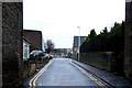
View of New Road, Forfar
Picture taken from near its junction with Little Causeway. The building at the extreme far end is Strathmore Primary School.
Image: © Alan Morrison
Taken: 3 Mar 2009
0.01 miles
2
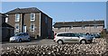
Rosemount
Just off New Road, the original house, on the left, has been converted into flats, and its gardens filled up with council housing and parking.
Image: © Anne Burgess
Taken: 20 Apr 2009
0.03 miles
3
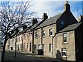
Little Causeway
Attempts to preserve this old part of the town have included closing most of it to traffic, and the original cobbles have been retained. Unfortunately no solution seems to have been found for the ultra-modern scourge of the wheelie bin.
Image: © Anne Burgess
Taken: 18 Feb 2009
0.03 miles
4
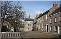
Little Causeway
The sun only illuminates the façades of the houses on the south side of Little Causeway in the evening in spring and summer. The projecting wing is part of the Friarage, and the steeple of the Parish Kirk is beyond it. Notice that the street is still cobbled with round stones, not even the shaped setts which were a later innovation. They are not pleasant to walk over!
Image: © Anne Burgess
Taken: 2 Apr 2010
0.03 miles
5
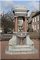
Webster Fountain
This edifice of pink and grey granite stands in the middle of Little Causeway. This Image] is the plaque on the face to the left.
Image: © Anne Burgess
Taken: 2 Apr 2010
0.03 miles
6
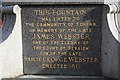
Plaque on Webster Fountain
This is the explanatory plaque on Image The Websters were prominent among the town council in the 18th and 19th centuries. For the benefit of non-Scots, a bailie, in this context, is roughly the Scottish equivalent of an alderman.
Image: © Anne Burgess
Taken: 2 Apr 2010
0.03 miles
7
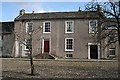
7 and 8 Little Causeway
This plain late 18th century house is embellished by a double stair Image] and a decorative pend Image] on the right leading through to the garden behind. It is a Category B listed building.
Image: © Anne Burgess
Taken: 6 Apr 2010
0.03 miles
8
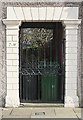
Pend at 7 and 8 Little Causeway
This is the detail of the pend which gives access to the garden behind Image It has channelled Roman doric pilasters and voussoirs.
Image: © Anne Burgess
Taken: 2 Apr 2010
0.03 miles
9
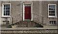
Stairs at 7 Little Causeway
Although at first glance the façade of Image] looks symmetrical, closer examination reveals that there is a larger space between the door and the window to the right than there is to the left, giving the illusion that the stairs are not the same length.
Image: © Anne Burgess
Taken: 2 Apr 2010
0.03 miles
10
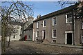
4 to 8 Little Causeway
The 17th century Friarage at Nos 4 to 5 and the 18th century house at Nos 7 to 8 stand on either side of a much smaller early 18th century house, the forestair of which was removed to insert a garage for the Friarage.
Image: © Anne Burgess
Taken: 2 Apr 2010
0.03 miles