IMAGES TAKEN NEAR TO
FORFAR, DD8 1TT
Introduction
This page details the photographs taken nearby to DD8 1TT by members of the Geograph project.
The Geograph project started in 2005 with the aim of publishing, organising and preserving representative images for every square kilometre of Great Britain, Ireland and the Isle of Man.

There are currently over 7.5m images from over14,400 individuals and you can help contribute to the project by visiting https://www.geograph.org.uk
Image Map
Images are licensed for reuse under creativecommons.org/licenses/by-sa/2.0
Notes
- Clicking on the map will re-center to the selected point.
- The higher the marker number, the further away the image location is from the centre of the postcode.
Image Listing (8 Images Found)
Images are licensed for reuse under creativecommons.org/licenses/by-sa/2.0
Image
Details
Distance
1
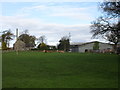
West Mains of Kincaldrum
West Mains of Kincaldrum, viewed from the east.
Image: © Scott Cormie
Taken: 28 Apr 2018
0.03 miles
3
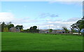
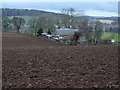
West Mains Farm
This farm is situated east of Glamis and west of the A90 Dundee/Aberdeen road to the south of Forfar.
Image: © Christopher Gillan
Taken: 28 Jan 2006
0.03 miles

5
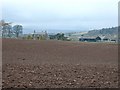
View of Kinnettles, Angus
This picture was taken from the West Mains of Kincaldrum farm road and shows the Kinnettles area with a fair view of Strathmore, with the Grampian Mountains in the background. Kinnettles House can be clearly seen at the top right of the picture.
Image: © Alan Morrison
Taken: 6 Jan 2008
0.06 miles
6
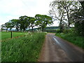
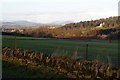
Minor road near West Mains of Kincaldrum
Towards Mains of Kinnettles.
Image: © JThomas
Taken: 11 Jun 2021
0.11 miles
7
Cottage at West Mains Farm near Forfar
Image: © Christopher Gillan
Taken: 28 Jan 2006
0.11 miles
8
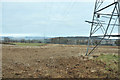
Pylons crossing farmland near West Mains
Image: © Steven Brown
Taken: 18 Dec 2012
0.16 miles