IMAGES TAKEN NEAR TO
Glamis, FORFAR, DD8 1SZ
Introduction
This page details the photographs taken nearby to DD8 1SZ by members of the Geograph project.
The Geograph project started in 2005 with the aim of publishing, organising and preserving representative images for every square kilometre of Great Britain, Ireland and the Isle of Man.

There are currently over 7.5m images from over14,400 individuals and you can help contribute to the project by visiting https://www.geograph.org.uk
Image Map
Images are licensed for reuse under creativecommons.org/licenses/by-sa/2.0
Notes
- Clicking on the map will re-center to the selected point.
- The higher the marker number, the further away the image location is from the centre of the postcode.
Image Listing (6 Images Found)
Images are licensed for reuse under creativecommons.org/licenses/by-sa/2.0
Image
Details
Distance
2
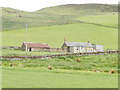
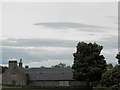
Farmland around Wedderleys
The house at Wedderleys has clearly been replaced with something grander than was seen by Douglas Nelson when he passed nearby in June 2013 - http://www.geograph.org.uk/photo/3511675.
Image: © Trevor Littlewood
Taken: 20 Oct 2018
0.09 miles
3
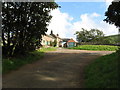
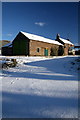
Wester Rochelhill Farm.
Wester Rochelhill Farm is situated on a narrow road not far from Glamis.
Image: © Christopher Gillan
Taken: 10 Oct 2006
0.14 miles
4
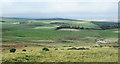
Road from A928 to Holemill
Road past West Rochellhill with Denoon Law in background.
Image: © Dan
Taken: 23 Nov 2008
0.15 miles
6
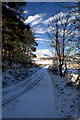
Wester Rochelhill
Scots ruch hill- 'rough hill' with an extra 'hill' added later; part of the lands of Glamis. Hill in Denoon Glen, from which the farms of Rochelhill Mains and Wester Rochellhill take their name. (from:Dorward, D. 2004. The Sidlaw Hills. The Pinkfoot Press).
Image: © Dan
Taken: 23 Nov 2008
0.18 miles