IMAGES TAKEN NEAR TO
Craig O'Loch Road, FORFAR, DD8 1BY
Introduction
This page details the photographs taken nearby to Craig O'Loch Road, DD8 1BY by members of the Geograph project.
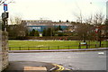
The Geograph project started in 2005 with the aim of publishing, organising and preserving representative images for every square kilometre of Great Britain, Ireland and the Isle of Man.

There are currently over 7.5m images from over14,400 individuals and you can help contribute to the project by visiting https://www.geograph.org.uk
Image Map
Images are licensed for reuse under creativecommons.org/licenses/by-sa/2.0
Notes
- Clicking on the map will re-center to the selected point.
- The higher the marker number, the further away the image location is from the centre of the postcode.
Image Listing (130 Images Found)
Images are licensed for reuse under creativecommons.org/licenses/by-sa/2.0
Image
Details
Distance
2
Myre Road, Forfar at its junction with Queenswell Road
Image: © Alan Morrison
Taken: 15 Feb 2009
0.03 miles
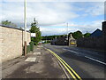
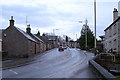
3
Craig O' Loch Road, Forfar approaching its junction with West High Street, Glamis Road and Dundee Loan
Glamis Road leads to the right and West High Street is to the left.
Image: © Alan Morrison
Taken: 26 Feb 2010
0.04 miles
4
Strathmore Mineral Water, Forfar
Picture taken from Myre Road, Forfar, near its junction with Queenswell Road.
Image: © Alan Morrison
Taken: 15 Feb 2009
0.05 miles
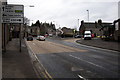
5
Craig O' Loch Road, Forfar looking south
Picture taken about 100 yards south of its junction with Myre Road. At the junction in the distance, West High Street is to the left, Glamis Road to the right and Dundee Loan straight ahead.
Image: © Alan Morrison
Taken: 3 Mar 2009
0.05 miles
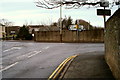
7
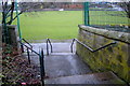
Steps at north end of Stark's Close, Forfar
The steps lead into The Myre park.
Image: © Alan Morrison
Taken: 3 Mar 2009
0.05 miles
8
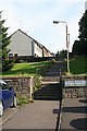
Steps to Lyninghills
The steps offer direct pedestrian access from the housing estates of Laurelbank and Lyninghills to the West High Street. As children, in winter, we used to sledge down the grassy slope, which in those days was part of a field and much longer. The important things was to get through the gate in the wall; failure to get through the gap tended to result in very sore heads or feet, depending on how you used your sledge.
Image: © Anne Burgess
Taken: 13 Aug 2010
0.06 miles
9
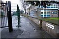
Stark's Close, Forfar
This close leads from West High Street to The Myre public park. Tayside Police Divisional Headquarters can be seen on the right of the photograph.
Image: © Alan Morrison
Taken: 3 Mar 2009
0.07 miles