IMAGES TAKEN NEAR TO
Scotscraig, TAYPORT, DD6 9PA
Introduction
This page details the photographs taken nearby to DD6 9PA by members of the Geograph project.
The Geograph project started in 2005 with the aim of publishing, organising and preserving representative images for every square kilometre of Great Britain, Ireland and the Isle of Man.

There are currently over 7.5m images from over14,400 individuals and you can help contribute to the project by visiting https://www.geograph.org.uk
Image Map (Loading...)


Getting Data...Please wait
Leaflet Map data © OpenStreetMap
Images are licensed for reuse under creativecommons.org/licenses/by-sa/2.0
Notes
- Clicking on the map will re-center to the selected point.
- The higher the marker number, the further away the image location is from the centre of the postcode.
Image Listing (10 Images Found)
Images are licensed for reuse under creativecommons.org/licenses/by-sa/2.0
Image
Details
Distance
2
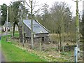
Doocot and daffodils
Scotscraig doocot seen from the east.
Image: © James Allan
Taken: 7 Apr 2008
0.20 miles
3
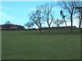
Scotscraig Mains Farm
Seen from the south
Image: © James Allan
Taken: 2 Mar 2006
0.21 miles
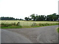
4
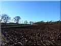
Freshly ploughed
Rich soil in a field on Scotscraig estate.
Image: © James Allan
Taken: 5 Mar 2012
0.22 miles
5
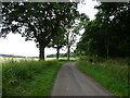
Minor road beside woodland, Scotscraig
Towards the Inverdovat.
Image: © JThomas
Taken: 23 Jul 2021
0.23 miles
6
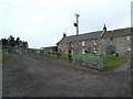
Farm buildings at Scotscraig
Looking west, towards the archway that leads into the walled garden.
Image: © James Allan
Taken: 7 Apr 2008
0.23 miles
7
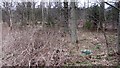
Woodland, Scotscraig
The low, eastern tail of the Ochil Hills carries on the same igneous theme as the big stuff to the west. Scotscraig Estate has a few craggy hillsides and a lot of attractive woodland.
Image: © Richard Webb
Taken: 25 Feb 2012
0.23 miles
8
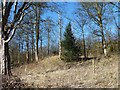
Evergreen amid deciduous
A holly bush surrounded by leafless trees on the Scotscraig estate.
Image: © James Allan
Taken: 5 Mar 2012
0.24 miles
9
Field entrance and road to Scotscraig Mains
Image: © JThomas
Taken: 23 Jul 2021
0.24 miles
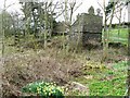
10
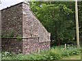
Scotscraig Doocot
A Category B listed building dating from the 1700s, this doocot (the Scottish word for dovecote, or dovecot) is described on its official listed building write-up as having a 'stepped rat course'. This not only is a term I have never come across before - there is also no mention of the term anywhere online.
The author is obviously referring to the stonework protruding from the wall about halfway up the building. Anything along these lines is usually referred to in architecture as a string course. That is, apart from a handful of doocot descriptions available online. So the assumption has to be that they were necessary to stop actual rats shimmying up the wall and getting through the entrance holes to devour the pigeons inside.
One article I found on the subject of rats eating pigeons said that they will if they can, and since pigeons are famous for eating whatever comes their way too, the tone of the piece seemed to be 'what goes around, comes around'! Incidentally pigeons are sometimes referred to as 'rats with wings'.
Image: © Ian Dodds
Taken: 9 Jun 2021
0.24 miles